Aviation Investigation Report A09Q0203
Controlled Flight into Terrain
Exact Air Inc. Beech A100 C-GPBA
3 nautical miles NW
Chicoutimi/Saint–Honoré Airport, Quebec
The Transportation Safety Board of Canada (TSB) investigated this occurrence for the purpose of advancing transportation safety. It is not the function of the Board to assign fault or determine civil or criminal liability. This report is not created for use in the context of legal, disciplinary or other proceedings. See Ownership and use of content.
-
Table of contents
Summary
The Beech A100 (registration C–GPBA, serial number B–215) operated by Exact Air Inc. as flight ET822 was on an instrument flight rules flight between Val–d'Or and Chicoutimi/Saint–Honoré, Quebec, with 2 pilots and 2 passengers on board. At 2240 Eastern Standard Time, the aircraft was cleared for an RNAV (GNSS) Runway 12 approach and switched to the aerodrome traffic frequency. At 2250, the International satellite system for search and rescue detected the aircraft's emergency locator transmitter signal. The aircraft was located at 0224 in a wooded area approximately 3 nautical miles from the threshold of Runway 12, on the approach centreline. Rescuers arrived on the scene at 0415. The 2 pilots were fatally injured, and the 2 passengers were seriously injured. The aircraft was destroyed on impact; there was no post crash fire.
1.0 Factual Information
1.1 History of the Flight
The 2 pilots were based in Baie–Comeau, Quebec, and normally flew out of the Exact Air Inc. base at Baie–Comeau Airport (CYBC). At 1130 Footnote 1, the crew was called to fly from Chicoutimi/Saint–Honoré (CYRC) Airport to Val–d'Or (CYVO) and return. The crew departed Baie Comeau by car at around 1300, arriving at CYRC at approximately 1630. The plan was to leave at 1800 with 7 passengers for CYVO, then return to CYRC with 2 passengers. The aircraft took off from CYRC at 1800 and landed at CYVO at 1933.
Refuelling was delayed at CYVO and was not completed until 2105. The aircraft was filled with approximately 2500 pounds of fuel, roughly 1 h 52 minutes of extra fuel above the minimum required by regulation using the Bagotville (CYBG) Airport as an alternate.
The copilot contacted the Québec flight information centre (FIC) for an update on the weather forecast and conditions at CYBG. The 2 passengers boarded the aircraft and sat in the last 2 side–by–side seats located at the rear of the aircraft. The flight departed CYVO at 2133 and climbed to its cruising altitude of flight level 190. The copilot was the pilot flying (PF) Footnote 2, while the pilot–in–command assumed the duties of the pilot not flying (PNF). Footnote 3
At 2215, the crew contacted the Québec FIC for the latest weather conditions, as well as the runway conditions at CYRC, Roberval (CYRJ) and CYBG. The latest available runway conditions for CYRC had been issued at 1625 and at 1642 for CYRJ. Recent runway conditions were only available for CYBG.
At 2230, the crew was issued the CYBG altimeter setting which was 29.34 inches of mercury; the aircraft began its descent a few minutes later. At 2240, the crew was cleared for the RNAV Runway 12 approach via the XESUT fix (Figure 1).
At 2245, the flight was transferred to 118.4 MHz. As the CYRC tower was closed at the time, the frequency was to be used as the aerodrome traffic frequency (ATF). At that point, the aircraft was flying between the XESUT and RABAD fixes, at an altitude of 5800 feet above sea level (asl) Footnote 4 at a ground speed of 250 knots.

At 2246, the aircraft passed the RABAD intermediate approach fix at an altitude of 3900 feet asl with a ground speed of 200 knots.
At 2249, the crew transmitted on the ATF frequency that it had reached RABAD and would be on final shortly for Runway 12. However, according to the radar data, this transmission corresponds to the moment at which the aircraft passed the ESRIX final approach fix. At that point, the aircraft was at an altitude of 1100 feet asl with a ground speed of 100 knots, which, under the existing conditions, was consistent with an indicated airspeed of approximately 130 knots.
The last radar position was recorded at 2249, 0.5 nautical miles (nm) after crossing the ESRIX fix, still at 1100MHzfeet asl, i.e. approximately 600 feet above ground level (agl), at a distance of 4.5 nm from the threshold of Runway 12.
The company was expecting the aircraft's arrival. A few minutes after the 2249 call from C–GPBA on the 118.4 MHz frequency, the runway lights were lit.
At 2250, the Canadian Mission Control Centre (CMCC) received a message that the COSPAS SARSAT Footnote 5 system had detected an emergency locator transmitter (ELT) signal on the 406 MHz frequency. The signal originated from C–GPBA and steps were taken to find the emergency contact person.
At 2306, the CMCC contacted Exact Air Inc. personnel, who confirmed that C–GPBA was on a flight from CYVO to CYRC, that the runway lights were lit, but that the aircraft had not yet landed.
At 2318, the CMCC contacted the Montreal area control centre (ACC) to check the position of C–GPBA. Montreal ACC then contacted the controller at the Bagotville terminal to check on the status of flight ET822. The ACC was advised that the aircraft had been switched over to the ATF frequency at 2245 and that its last radar position corresponded to 4 nm on final approach to Runway 12. However, the crew had not yet confirmed that it was on the ground at CYRC. The rescue coordination centre must be informed when no communication has been received from an aircraft within a period of 30 minutes after the time a communication should have been received Footnote 6. Five minutes still remained before the 30–minute uncertainty phase would have been reached.
At 2325, the Sûreté du Québec (Quebec provincial police) was informed that the aircraft might have crashed in the final approach area of Runway 12 at Saint–Honoré Airport. A command post was set up at Saint–Honoré Airport and search efforts were coordinated with volunteers, including company personnel, to deploy snowmobiles, sleds and ambulances.
At 2346, the first call from a cell phone belonging to one of the passengers was received by the 911 emergency services, but communication was lost several times. Two passengers were in the aircraft, which was inverted, and both pilots were unconscious. At that time, it was not possible to determine the cell phone's location.
By 0130, the location coordinates of the cell phone used by the passenger had been determined and were passed on to the Sûreté du Québec. Snowmobilers were sent towards this position. However, it was 5 nm to the southeast of the aircraft.
The Joint Rescue Coordination Centre (JRCC) dispatched a Hercules aircraft from the Trenton, Ontario, base. The Hercules arrived on the scene at approximately 0215 and, by homing in on the 121.5 MHz ELT signal, was able to locate the aircraft at 0224. At 0315, flares were deployed to help the snowmobilers find the aircraft on the ground.
At approximately 0415, rescuers on the ground located the aircraft in a wooded area about 3 nm from the threshold of Runway 12. A Griffon helicopter dispatched from the Bagotville base arrived at the accident site at 0430. The survivors (the 2 passengers) were transported by helicopter to the hospital; they were seriously injured. Both pilots were killed on impact with the ground.
1.2 Wreckage and Impact Information
1.2.1 General
The initial point of impact with the treetops occurred 170 feet north of the Runway 12 final approach course, approximately 3 nm before the runway, which corresponds to the approximate position of the OTUTI intermediate approach fix (Appendix A).
From its last radar position, at an altitude of 1100 feet asl and travelling at a ground speed of 100 knots, the aircraft covered a distance of 1.59 nm before striking treetops at a height of 525 feet asl. The average descent rate was, therefore, approximately 600 feet per minute.
After initial contact with the treetops, the aircraft travelled 340 feet before the right wing was severed by large trees. The aircraft then began a pronounced roll to the right, hitting trees that partially severed its left wing. It then struck the ground and tumbled, finally coming to a rest inverted, 300 feet away (Photo 1). The wreckage was transported to the TSB Laboratory.

1.2.2 Damage to the Aircraft
The nose of the aircraft sustained heavy damage upon impact with the ground. The fuselage was breached in spots due to the compressive forces exerted on the right side and the tensile forces exerted on the left. Only the passenger cabin retained sufficient shape necessary for survival.
1.2.3 Fire
The aircraft's fuel tanks, located in the wings, ripped open when the wings were severed following impact with the trees. Most of the fuel was spilled before the aircraft came to a stop. There was no post–impact fire.
1.2.4 Other Damage
Damage to the environment was limited to the trees that were struck and the approximately 900 litres of fuel spilled on the snow–covered ground and surrounding vegetation.
1.3 Survival Aspects
The cockpit was severely compressed on impact with the ground and, as a result, there was insufficient space remaining to allow the 2 pilots to survive. The passenger cabin was damaged by compressive and tensile forces, causing a significant breach in the structure. However, the passenger cabin space preserved its initial shape.
Six of the 8 seats were ripped from their moorings. The seat occupied by the passenger in the left rear position became detached, struck the passenger on the right side then came to rest at the front of the cabin, with the passenger still attached. The seat occupied by the passenger in the right rear position remained anchored to the structure with the passenger still attached.
The main cabin door was obstructed by tree branches and could not be opened. The emergency exit above the right wing was jammed as a result of fuselage deformation and could not be used either. No emergency lights were available to the passengers, who huddled together and used sheepskin seat covers to protect themselves against the cold while waiting for help to arrive.
A passenger made several 911 emergency calls on a cell phone to report the aircraft accident.
To improve the safety of Canadians, the Canadian Radio–television and Telecommunications Commission (CRTC) required wireless service providers to improve their 911 services by 01 February 2010. Footnote 7 These enhanced 911 services (E911) were to make it easier to locate a person making a 911 call from a cell phone, particularly in an emergency when the person cannot speak or indicate his or her position.
Cell phone providers “use the Global Positioning System (GPS) or triangulation technology and then automatically transmit the caller's location to the call centre operator. This allows emergency responders to determine a caller's location generally within a radius of 10 to 300 metres from the cellphone.”
Footnote 8
1.4 Meteorological Information
At 1900, a deep low pressure system over Lake Huron was moving in a northeasterly direction towards the Val–d'Or area and Lac St–Jean at approximately 20 knots. As a result, all of southern Quebec was covered by a layer of cloud from 2000 feet to 20 000 feet asl, accompanied by light to moderate snow showers and areas of scattered heavy snow showers, all of which occasionally reduced visibility to 0.25 statute miles (sm) (Appendix B).
No aviation routine weather reports (METAR) are available at the CYRC airport.
At 2300, observations at CYBG, approximately 15 nm south of CYRC, indicated winds 110° True (T) at 21 knots gusting to 31 knots with a ground visibility between 3⁄4 and 1 1⁄4 sm in light snow and blowing snow. The ceiling was at 4200 feet agl, the surface temperature −7°C, the dew point −8°C and the altimeter setting 29.32 inches. Radar images from Lac au Castor (WMB) showed a significant area of precipitation in the CYRC area between 2240 and 2250.
The weather available to the crew was the amended aerodrome forecast (TAF) for CYBG issued at 1655, valid from 1600 on 09 December 2009 until 1600 on 10 December 2009, indicated the following: winds 090° T at 25 knots gusting to 40 knots, the ground visibility 6 sm in light snow and blowing snow, with a ceiling at 3000 feet agl. Between 1600 and 2100, temporary conditions may reduce the visibility to one sm in light snow and blowing snow, with obscured sky conditions that would result in a vertical visibility of 800 feet. From 2100 the visibility was forecast as 1⁄2 sm in moderate snow and blowing snow and a vertical visibility of 500 feet with a temporary condition between 2100 and 1000 the next day of 1⁄4 sm in heavy snow and blowing snow and a vertical visibility of 200 feet.
In accordance with the instrument flight rules (IFR), the flight plan included an alternate airport, which in this case was CYBG. According to the Canadian Aviation Regulations (CARs) Footnote 9, to qualify as an appropriate alternate, the weather at CYBG should have forecast conditions at or above the minimum specified in the Canada Air Pilot (CAP), i.e. one sm at the expected time of arrival. When the weather conditions were updated before departure from CYVO, the CYBG TAF did not meet the CARs requirements for an alternate airport, because the visibility was forecast as low as 1⁄4 sm for the specified period.
Ground visibility at night is not necessarily representative of flight visibility. Depending on the type of lighting, the distance at which a light can be seen in flight may be twice that as could be seen on the ground. Some countries, such as those of the European Union Footnote 10, have recognized this phenomenon and have increased the ground-observed visibility to establish a converted visibility value. This converted value is used to determine minima for instrument approaches.
1.5 Crew Information
1.5.1 General
The pilot–in–command (PIC) held a valid airline transport pilot licence issued in September 2008 and had approximately 3500 hours of total flying time, including 1000 hours on the Beech A100 (BE10). The PIC had been working for the company since November 2007 and had completed a pilot proficiency check (PPC) on the BE10 in July 2009. The PIC was also a flight instructor on the BE10.
The copilot had completed his initial flight training at CYRC and held a valid commercial pilot licence issued in September 2006 along with a group I instrument rating. The copilot had been working for the company since March 2008 and completed a pilot proficiency check (PPC) on the BE10 in April 2009. The copilot had accumulated approximately 1000 hours of total flying time, of which 150 hours were on the BE10.
The flight crew was licenced and qualified for the flight in accordance with existing regulations.
The pilot and copilot were critically injured and died immediately following the accident. Toxicology testing of the pilots did not reveal any pre–existing conditions or the presence of any substance that might have impeded the pilots' performance. A review of the pilots' medical records by Transport Canada (TC) did not reveal any medical factors or pathologies that could have affected the performance of their duties.
1.5.2 Task–induced Fatigue
In the days preceding the accident, the pilot and the copilot had benefited from 2 and 3 days off, respectively, followed by 1 day of flying together. On the day before the accident, they had completed 2 return flights between Baie–Comeau and Rimouski, starting their work day at 1430 and finishing at 2335.
On the day of the accident, the crew was called at 1130 for a flight from CYRC to CYVO. Take off was scheduled for 1800, with the flight returning to CYRC at approximately 2200. At the start of their work day, there was no indication that the crew might be fatigued due to a lack of sleep or any health–related issue. Moreover, the crew had benefitted from a period of rest in accordance with the CARs. The crew ate a meal at Saint–Honoré Airport before initiating pre–flight preparations.
The crew travelled from Baie–Comeau to Saint–Honoré by car, covering the 325–km distance in 4 hours, in snow showers and blowing snow. As sunset was at 1549, part of the trip and all of the flight took place in darkness. The pilots flew manually on the outbound and return legs in low visibility and conditions of low–altitude turbulence.
Performing tasks related to driving a car and piloting an aircraft under such conditions requires heightened mental concentration and visual attention. Such intense concentration over an extended period of time typically results in task–induced fatigue that negatively affects visual and cognitive performance. The decreased cognitive performance in turn has a negative impact on working memory. Working memory enables information to be temporarily stored for the purpose of making mental calculations. Footnote 11
1.6 Company Information
1.6.1 General
Exact Air Inc. holds a valid air operator's certificate. Its headquarters are located at CYRC. In addition to CYBC, the company operates out of 3 other bases located at Havre Saint Pierre, Port–Menier and Sept–Îles.
At the time of the occurrence, Exact Air Inc. operated a fleet of 42 aircraft comprised of the following types: Beech A100 (BE10), Piper PA–31, Piper PA–34, Cessna 402, Cessna 310, Cessna 182, Cessna 172 and Cessna 152. Depending on the type of aircraft used, operations were conducted pursuant to Subpart 3, Part VII of the CARs. During the occurrence flight, the aircraft was operated as an air taxi under Subpart 3. The BE10 (C–GPBA) was based in Saint–Honoré, whereas the crew normally worked out of the base at CYBC. As such, the crew did not fly this BE10 very often.
Exact Air Inc. uses a Type D (self–dispatch) operational control system Footnote 12 under which the operations manager delegates operational control of the flight to the pilot–in–command, but retains responsibility for all flight operations. Additionally, a person who is qualified and knowledgeable in the air operator's flight alerting procedures shall be on duty or available when IFR or night VFR flight operations are being conducted. Exact Air Inc. had a person on duty for the occurrence flight.
1.6.2 Standard Operating Procedures
The company's operations manual and standard operating procedures (SOP) comply with the Commercial Air Services Standards (CASS); however the SOPs are not subject to TC approval.
The SOPs state that during an instrument approach, the PF manoeuvres the aircraft to remain within the limits of the approach and focuses his attention exclusively inside the aircraft. The PNF focuses his attention both inside and outside the aircraft and must complete the following actions:
- Make standard calls
- Advise of any abnormal indications
- Perform timing requested by the PF
- Call out
“Vertical Contact”
when the ground is sighted - Call out
“Approach Lights”
or“Runway in Sight”
when these visual references are observed, which will ensure that the aircraft can be safely landed
The Before landing checklist must be completed before the FAF. Generally, the PNF makes the calls, otherwise they are made by the PF. For the RNAV (GNSS) Runway 12 approach where no deviations are encountered, the following calls are required to be made:
”Transition, altimeter … indicating… crosscheck“1000 feet above cleared altitude Example: 15 000 for 14 000 100 above cleared altitude
”100 to go“At FAF
”FAF: altitude, no flags“1000 feet before minimum
”1000 above“100 feet before minimum
”100 above“Visual contact
”Vertical Contact“
”Runway in Sight,“
”Approach Lights“Minimum altitude
”Altitude Contact“or
”No Contact“Missed approach point (MAP)
”Minimum Contact“or
”No Contact“If contact
”Continue“If no contact
”Go around“
As the aircraft was not equipped with a cockpit voice recorder (CVR), it was not possible to determine if these calls were made in accordance with the SOPs.
1.6.3 Crew Training
Exact Air Inc. has an operations specification Footnote 13 authorizing GPS–based instrument approaches for which the crew had been trained as per the CASS.
According to the CASS, Footnote 14 controlled flight into terrain (CFIT) avoidance training must be provided during initial and biennial ground training, which the crew had received. Such training must essentially cover:
- Factors that may lead to CFIT accidents and incidents
- Operational characteristics, capabilities, and limitations of GPWS (if applicable)
- CFIT prevention strategies
- Methods of improving situational awareness
- Escape manoeuvre techniques and profiles applicable to the aeroplane type
The International Civil Aviation Organization (ICAO) states that the fundamental purpose of crew resource management (CRM) training is “to improve flight safety through the effective use of error management strategies in individual as well as systemic areas of influence”
and proposes the integration of threat and error management (TEM) into CRM. Footnote 15
Further to TC's response to recommendation A95–11, issued by the TSB in 1995, CRM training is now required by air transport operators operating pursuant to section 705 of the CARs. However, this training is not required for commuter operations pursuant to section 704 of the CARs or an air taxi service pursuant to section of the CARs.
Further to the CFIT accident involving a Beech King Air at Sandy Bay, Saskatchewan, on 07 January 2007, the TSB made recommendation A09–02:
In light of the risks associated with the absence of recent CRM training for air taxi and commuter crew members, the Board recommended that:
The Department of Transport require commercial air operators to provide contemporary crew resource management (CRM) training for Canadian Aviation Regulations (CARs) subpart 703 air taxi and CARs subpart 704 commuter pilots.
(A09–02)
The CARs still do not require CRM training for air taxi or commuter operators and, consequently, the pilots of C–GPBA had not received any.
In its response on 14 January 2010, TC agreed to the recommendation in principle and expected to present a risk assessment and any related recommendation to the Civil Aviation Regulatory Committee (CARC) in the spring of 2010. The resulting recommendation from CARC will trigger the rulemaking process.
In its response on 21 January 2011, TC indicated that it had completed its risk assessment. The CARC agreed to a balanced approach, including acceptance of TSB Recommendation A09–02, a regulatory measure, training and guidelines. The project plan is currently being reviewed in light of existing priorities.
The risk assessment conducted by TC validated the TSB's finding as to risk regarding the absence of recent CRM training and broadened the scope of the safety deficiency to include commercial single–pilot operations. The risk assessment also concluded that current training issues extended beyond CARs 703 and 704 pilots, and recommended better defined training requirements and integrating contemporary CRM into existing training requirements.
On 19 September 2011, the Civil Aviation Regulatory Committee directed that a Focus group be established as soon as possible in the fall to address this issue. This newly formed focus group met for the first time on 23 January 2012. TC has continued to make progress in implementing TSB Recommendation A09–02. The accepted course of action, if implemented, would substantially reduce or eliminate the deficiency identified in Board Recommendation A09–02. The TSB considers that TC's response indicates a Satisfactory Intent.
1.7 Aircraft Information
1.7.1 General
The aircraft was certified and equipped in compliance with existing regulations. Footnote 16 Maintenance was carried out by Exact Air Inc.'s approved maintenance organization (AMO) in accordance with a maintenance schedule Footnote 17 approved by TC. The aircraft weight and centre of gravity were within the limits prescribed by the manufacturer.
1.7.2 Altimeters
Pressure altimeters are calibrated to indicate true altitude under international standard atmosphere (ISA) conditions. Any deviation from ISA will result in an erroneous reading on the altimeter. In a case when the temperature is lower than the ISA, the true altitude will be lower than the indicated altitude. Therefore, temperature corrections for cold weather must be added to the published altitudes on instrument approach charts when the temperature is below 0°C.
As the surface temperature was −7°C, a correction needed to be made to the approach fix crossing minimum altitudes as well as to the minimum descent altitude (MDA). A correction of 67 feet needed to be added to the published altitude at the final approach fix (FAF), a correction of 40 feet in the minimum published altitude at the OTUTI fix and a correction of 30 feet to the MDA.
Normally, the instrument approach procedure is conducted using the current CYRC altimeter setting. At the time of the approach, however, the CYRC control tower was closed and no advisory service was available. However, the instrument approach allows the use of the CYBG altimeter setting with the application of a 30–foot correction to the published altitudes.
Therefore, with the corrections for cold weather and the use of the CYBG remote altimeter setting, the corrected FAF crossing altitude was 1397 feet, the corrected minimum published altitude to the OTUTI fix was 970 feet asl and the corrected MDA was 920 feet asl.
The investigation did not permit to determine whether these corrections had been applied. In addition, the 2 altimeters were not equipped with a target altitude bug nor was it a requirement.
The C–GPBA was equipped with a radio altimeter. Its decision height bug had been set to approximately 1500 feet agl, which did not correspond to any specific altitude for the RNAV (GNSS) Runway 12 approach. When the agl height falls below the bug setting, the “DH”
light on the radio altimeter illuminates. The CARs do not require that SOPs include directives on the use of radio altimeters for non–precision approaches. No such procedures were in place.
1.7.3 Emergency Locator Transmitter
The aircraft was equipped with a KANNAD ELT, model 406AF-COMPACT, serial number 259215, which could transmit on both 121.5 MHz and 406 MHz frequencies. The emergency locator transmitter (ELT) was not damaged by the accident and it activated on impact. However, the antenna installed on the back of the cabin was damaged.
Owners and operators are responsible for registering beacons with the Canadian Beacon Registry Footnote 18. C–GPBA's ELT was not registered. Consequently, emergency contact information was not available. Additional efforts were required of CMCC staff to locate and contact a person responsible for flight following in case of an emergency.
1.7.4 Autopilot
On 19 November 2009, C–GPBA's autopilot became inoperative as a result of pitch oscillations. The aircraft was returned to service without an autopilot as per the company's Maintenance control manual (MCM) and the CARs.
1.7.4.1 Cockpit Voice Recorders (CVR)
The CARs state that Footnote 19 “no person shall conduct a take–off in a multi–engine turbine–powered aircraft that is configured for six or more passenger seats and for which two pilots are required by the aircraft type certificate or by the subpart under which the aircraft is operated, unless the aircraft is equipped with a cockpit voice recorder.”
C–GPBA was a multi–engine, turbine–powered aircraft configured for 8 passengers. Its type certificate Footnote 20 allowed it to be operated by a single pilot. The aircraft was being used pursuant to Subpart 703 of the CARs,Footnote 21 which requires the presence of 2 pilots when operating an aircraft with passengers in IMC flight. However, Exact Air Inc. held an operations specificationFootnote 22 issued by TC that permits the operation of an aircraft with passengers on board in IMC flight without a second–in–command. In such a case, the CARs requirements governing pilotsFootnote 23 and additional equipmentFootnote 24, such as a functioning autopilot, must be respected. As the autopilot on C–GPBA was not operational, a second pilot was required.
Differing interpretations of the CVR requirement led some Quebec operators to challenge its application by TC before the courts. The Federal Court of Appeal ruled for the operators which allowed them to operate BE10s in commercial air taxi service without a CVR.
According to TC, the court's interpretation of the wording ran counter to the intention of the CARs. In November 2009, the Canadian Aviation Regulation Advisory Council (CARAC) developed a Notice of proposed amendment (NPA) to the CARs. The aim was to clarify that a CVR is always required when an aircraft of this type, configured for 6 or more passenger seats, is operated by 2 pilots. However, the CARs still had not been amended as of the beginning of 2012.
1.7.5 Terrain Awareness Warning System
1.7.5.1 Garmin TAWS
Two GPS devices (Garmin GNS–530 and GNS–430) were installed on the event aircraft in compliance with the supplemental type certificatesFootnote 25 of Garmin International and existing regulations. C–GPBA was Exact Air Inc.'s first BE10 to be equipped with GPS devices, but these did not incorporate either the wide area augmentation system (WAAS) or the terrain awareness warning system (TAWS). However, the Garmin 530W installed on the company's other BE10s include TAWS.
One of the features of the Garmin 530W TAWS is the forward looking terrain avoidance (FLTA) used to generate alerts and warnings when the aircraft is projected to come within a minimum established clearance value of terrain or obstacles. Any potential impact points are then depicted on the display.
FLTA provides an amber caution alert when the predicted impact is in approximately 30 seconds and is accompanied by one of several caution aural messages. When the estimated impact is in approximately 15 seconds, a red warning alert is generated with an associated “Pull Up”
aural message.
The premature descent alerting (PDA) feature detects that the aircraft is significantly below the normal approach path to a runway and generates an amber caution alert with a “Too Low Terrain”
aural message.
The Garmin's 530W TAWS satisfies TSO–C151b Class B requirements for certification.
1.7.5.2 United States
The Federal Aviation Administration (FAA) in the United States has required all commercially operated turbine-powered airplanes with 6 or more passenger seatsFootnote 26 to be fitted with a TAWS since 29 March 2001. According to the FAA's Instrument Procedures Handbook,Footnote 27 pilots can reduce their exposure to CFIT accidents by identifying risk factors and remedies before each flight. An additional measure involves equipping aircraft with TAWS. According to the FAA, this precaution alone could reduce CFIT accidents by over 90%.
1.7.5.3 European Economic Community
European Economic Community (EEC)Footnote 28 regulations require that operators install TAWS on all turbine powered aeroplanes having a maximum certificated take–off mass in excess of 5700 kg or a maximum approved passenger seating configuration of more than 9 seats.
1.7.5.4 Australian Transport Safety Bureau
The Australian Transport Safety Bureau (ATSB) issued a recommendationFootnote 29 on 09 March 2006 concerning the installation of TAWS on aircraft weighing less than 5700 kg to improve terrain awareness and, consequently, reduce the risk of CFIT accidents.
1.7.5.5 Transportation Safety Board of Canada
Following the CFIT accident involving a Hawker Siddeley northwest of Sandy Lake, Ontario, on 10 November 1993, the TSB issued recommendation A95–10:
Most turbo–prop aircraft, some carrying dozens of passengers, continue to operate without the added safety protection of GPWS. Therefore, the Board recommended that:
The Department of Transport require the installation of GPWS on all turbine–powered, IFR–approved, commuter and airline aircraft capable of carrying 10 or more passengers.
(A95–10)
In its response of 14 December 2005, TC noted that TAWS, the technology that supersedes GPWS, would certainly overcome the deficiencies inherent in GPWS. There is a strong possibility that the regulations will be published in Part I of the Canada Gazette in late 2005 or early 2006. In the package of new regulations, there are also regulations under CARs 605 requiring turbine–powered aeroplanes configured with more than 6 passenger seats to be equipped with Class B TAWS.
In its response of 07 February 2007, TC said the regulations were expected to be pre–published in the Canada Gazette Part I by April or May 2007, but this date has been pushed back to sometime in the fall of 2007.
In its response of 13 August 2008, TC stated that it is possible that the regulations may be published in the Canada Gazette Part I in 2008.
In its response of 15 February 2010, TC indicated that its CARAC consultation of the TAWS related NPAs and the drafting of regulations by Justice Canada were complete.
The proposed regulatory changes were pre–published on 03 December 2011, in the Canada Gazette, Part 1, Volume 145, No. 49. The proposed regulatory amendments would introduce requirements for the installation of TAWSs in private turbine–powered aircraft configured with six or more passenger seats, excluding pilot seats, and in commercial aircraft configured with six or more passenger seats, excluding pilot seats. Operators would have 2 years from the date on which the regulations come into force to equip their aircraft with TAWS.
The proposed regulatory amendment brought forward by TC, if adopted and implemented, will substantially reduce the safety deficiency identified in Recommendation A95–10. The TSB considers that TC's response indicates a satisfactory intent.
The risk of CFIT accidents is even greater for small aircraft, which venture further into remote, wild or mountainous terrain, but are not required to have the same ground proximity warning equipment as large airliners.
In its report on the circumstances surrounding the crash of a Beechcraft C99 Airliner in Moosonee, Ontario, on 30 April 1990, Footnote 30 the TSB noted with concern that, between 1976 and 1990, there were 170 CFIT accidents, with 152 fatalities, involving Canadian–registered, commercially operated small aircraft. In that same report, TSB indicated that, since GPWS became mandatory equipment on larger passenger-carrying aircraft, the number of CFIT accidents has decreased markedly for these aircraft. However, smaller aircraft do not require this type of warning equipment.
This safety issue is on the TSB's Watchlist and the TSB continues to be very concerned that, until the changes to regulations are put into effect, the deficiency will persist.
1.7.6 TSB Laboratory Examination and Analysis
C–GPBA was not equipped with a flight data recorder (FDR), nor was this required by regulation. Consequently, little data were available to establish the condition and flight path of the aircraft before the accident. The wreckage was transported to the TSB Laboratory for more detailed examination to establish its condition at the time of the accident.
1.7.6.1 Engines and Propellers
An examination of the engines determined that the integrity of the engine and propeller controls had been maintained. Teardown of the engines revealed no anomalies, other than the internal rub marks and deformation consistent with engines producing power at the time of impact.
Examination of the propellers did not reveal any pre–impact, mechanical anomalies. In addition, the observed marks and damage confirm that the propellers were in a positive angle and receiving power from the engines at impact.
1.7.6.2 Flight Controls and Landing Gear
A detailed examination of the controls, surfaces, cables and pulleys confirmed the integrity of the flight controls. No anomaly, condition or defect affecting the operation of the flight controls was observed. Examination of the flap actuators confirmed that they were working properly and that the flaps were in the approach position at the time of impact.
The nose wheel and left gear were severed and detached from the fuselage. Examination of the actuators revealed that the landing gear was down with all wheels extended at impact.
1.7.6.3 Instruments, Lights and Annunciator Panel
In March 2009, the aircraft's pitot–static system along with the 2 altimeters were inspected and certified. No anomalies were recorded in the log book following certification. At the accident site, the 2 altimeters showed an altimeter setting of 29.34 and 29.35 inches of mercury. Microscopic examination of the altimeter faces and internal mechanisms did not provide any reliable information on altimeter indications upon impact.
Examination of the radio altimeter established that the “DH”
alert light associated with the decision height was illuminated at the time of impact. It was, therefore, receiving electrical power and working normally.
The light bulbs used in the various annunciator panels were examined to determine which ones were illuminated upon impact with the ground. The GPS annunciator lights indicated that both were in approach mode, with no caution annunciator lights on. The autopilot panel lights were all out. The annunciator lights for the left and right generators and for fault warning were illuminated.
The landing lights were destroyed on impact. Examination of the landing light switches could not determine whether they were in the ON position at impact.
The screens of the 2 GPS units were shattered and the casings dented by the impact. The data cards were removed and it was determined that the database was valid until 17 December 2009; the approach fixes at Saint–Honoré were consistent with the RNAV (GNSS) instrument approach chart for Runway 12 in CAP. The 2 Garmin GPS models do not record flight path data making it impossible to determine precisely the aircraft's track once it left radar coverage.
1.7.6.4 Seats
An examination of the seats, anchors and tracks determined that their rated load had been exceeded during impact, which explains why 6 of the 8 passenger seats became detached.
1.8 Aerodrome Information
1.8.1 General
The CYRC airport is located in the municipality of Saint–Honoré de Chicoutimi and is operated by the Quebec Department of Transport. CYRC is a registered aerodrome, but its certification is no longer required under paragraph 302.01(1)(c) of the CARs.
The Saint–Honoré control tower is closed between 2030 and 0800. During this period, control services are not available and the tower's frequency is designated as the ATF frequency. As a result, no advisory service is available for commercial and private flights operating outside the control tower's hours of operation.
1.8.2 Aircraft Rescue and Firefighting Service
CYRC is not equipped with aircraft rescue and firefighting (ARFF) services, nor are they required by regulation. In the event of an emergency, the fire department in the municipality of Saint–Honoré, located a few kilometres away, can be at the airport in less than 6 minutes when called by tower personnel. However, when the control tower is closed, there is no one designated to report an accident to the Saint–Honoré fire department.
1.8.3 Runway and Approach Lights/Runway Lights
CYRC has 3 asphalt runways, including Runway 12/30, which measures 6087 feet long by 150 feet wide. The touchdown zone elevation (TDZE) Footnote 31 of Runway 12 is 537 feet asl. The airport is equipped with a type K aircraft radio control of aerodrome lighting (ARCAL) system, which enables all the runway lights to be activated for approximately 15 minutes at maximum intensity by pressing a microphone button 7 times on tower frequency 118.4 MHz. Runway 12 is equipped with centre line low-intensity (AD) approach lights, threshold lights, variable medium-intensity runway edge lights (3 settings), and a 2–bar visual approach slope indicator system (VASIS).
1.8.4 Runway Conditions
The CARs Footnote 32 state that “No person shall terminate an instrument approach with a landing unless, immediately before landing, the pilot–in–command ascertains, by means of radio communication or visual inspection:“
“the condition of the runway or surface of intended landing;“
and“the wind direction and speed.“
According to the aeronautical information manual (AIM), Footnote 33 “aircraft movement surface condition reports (AMSCR) are issued to alert pilots of natural surface contaminants, such as snow, ice or slush that could affect aircraft braking performance.“
Further, a NOTAM is issued on the AFTN network Footnote 34 when there is loose snow on the runway exceeding 0.25 inches in depth. All of this information is available as an advisory from an airport control tower or a flight service station (FSS) at uncontrolled aerodromes.
The final runway inspection at CYRC is usually conducted at approximately 1630, just before the departure of airport personnel. Afterwards, it is up to the pilot or the operator to contact those in charge of clearing the runway to ensure that it has been cleared. Airport personnel occasionally contact the operator to check whether any arrivals are planned for CYRC after the tower is closed.
On the day of the occurrence flight, the runway was inspected at 1625. Due to heavy snowfall and strong winds, the personnel in charge of clearing the runway returned to the airport at about 2210 for an additional check. There was no snow accumulation on Runway 12 at that time. Once the tower is closed, the frequency becomes an ATF rather than a mandatory frequency (MF). As such, no advisory service is available and there is no mechanism in place at CYRC to receive and then transmit observed runway conditions.
At 2215, the crew attempted to obtain runway condition information at CYRC from the Québec FIC before landing. Because the CYRC tower was closed, the FIC could not obtain an update on runway conditions and the latest available for CYRC had been issued at 1625, nearly 6 hours earlier.
The TSB Watchlist, released in March 2010, also addresses the risks of runway overruns and the importance of having accurate reports of runway surface conditions made available to pilots. The Air fact sheet, published by the TSB in conjunction with the Watchlist, points out that “more must be done to ensure safe landings”
and that “in bad weather, pilots need to receive timely information about runway surface conditions.”
1.8.5 Communications
The CARs Footnote 35 state that the pilot–in–command of an IFR aircraft who intends to conduct an approach to or a landing at an uncontrolled aerodrome shall report intentions regarding the operation of the aircraft:
- Five minutes before the estimated time of commencing the approach procedure, stating the estimated time of landing
- When commencing a circling manoeuvre
- As soon as practicable after initiating a missed approach procedure
The pilot–in–command shall also report the aircraft's position:
- When passing the fix outbound, where the pilot–in–command intends to conduct a procedure turn or, if no procedure turn is intended, when the aircraft first intercepts the final approach course
- When passing the final approach fix or 3 minutes before the estimated time of landing where no final approach fix exists
- On final approach
Omission of position reports is a systemic phenomenon previously identified by the TSB in 2007. Footnote 36
The Civil aviation daily occurrence reporting system (CADORS) contains many occurrence reports pertaining to non-compliance with mandatory frequency (MF) area communication procedures in Canada. For 2008 and 2009, CADORS contained 118 occurrence reports of non–compliance. Occurrences linked with ATF areas are rarely reported because the CARs do not require compliance with VFR communications procedures at uncontrolled aerodromes within an ATF area. However, the AIM states that these IFR reporting procedures “should also be followed by the pilot–in-–command at aerodromes with an ATF.”
Footnote 37
The crew communicated its position only once on frequency 118.4 MHz, “[Translation] approaching RABAD, soon final for Runway 12,”
at 2248:53. However, the position recorded by Bagotville radar at that precise moment corresponded to 0.4 nm before the FAF (ESRIX), i.e. 4.6 nm after crossing RABAD.
In light of this positional discrepancy, research was carried out by the TSB Laboratory to check the validity of the times recorded by the tower and by Bagotville radar. It was determined that the 2 recorders were using a common time source, i.e. GPS network time. The tower frequency recorded time was then compared with the time signal broadcast by the National Research Council, and the difference was 0.3 of a second.
The recording on frequency 118.4 MHz revealed a first series of 8 clicks starting at 2251:42, which, via the ARCAL system, activated all airport lighting including the approach lights for Runway 12. This series of clicks was followed by several additional series of clicks ending at 2252:44. However, as the crash occurred at about 2250, almost 2 minutes before the first series of clicks was recorded, the crew did not initiate the aerodrome lighting start–up sequence. As a result, the airport lights, approach lights and VASIS were not illuminated at the time of the accident.
There were no other aircraft in the air or on the ground in the Saint–Honoré area when the ARCAL system was activated, and the investigation was unable to determine the source of these transmissions. The TSB conducted a sound analysis to verify the origin of the transmissions producing the clicks. A comparison of the sonograms associated with the various recorded transmissions confirmed that C–GPBA was not the source of the transmissions producing the clicks that occurred after 2251.
1.9 Tests and Research
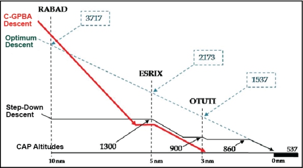
On 02 March 2010, the TSB conducted a series of test flights at CYRC airport to evaluate the RNAV (GNSS) Runway 12 approach. The first flight was conducted using an aircraft equipped with an FMS that charted an optimum descent path of 3°. The FMS calculated the fix crossing altitude for RABAD as 3757 feet asl, for ESRIX as 2169 feet asl, and for OTUTI as 1532 feet asl, approaching the runway threshold at 581 feet asl, or 44 feet above the surface of the runway.
The aim of the second flight, conducted at night, was to re–enact the occurrence approach. A BE10 from the company equipped with the same GPS models as C–GPBA was used for this purpose. The first RNAV (GNSS) Runway 12 approach began at the XESUT fix, flying the same descent profile as C–GPBA to the FAF crossing altitude, then descending to the minimum altitude before OTUTI. The second approach was flown using a step–down descent, tracking the altitudes published in CAP from XESUT to MDA.
The test flights established that, when a step–down approach is flown at the altitudes published in CAP, the aircraft is at minimum altitude, far from the runway threshold. The descent path from the FAF to the runway is shallow and significantly lower than the 3° optimum descent angle. As a result, the aircraft remained at the minimum obstacle clearance altitudes, near the ground, for longer periods than most of the other approaches flown by this crew.
The night flight revealed the presence of light sources along the approach path, i.e. the lights at a mine located approximately 4 nm from the threshold of Runway 12 and the lights of a service station located one nm from the threshold. However, the absence of lights in the vicinity of the accident site was also noted. According to available information, the intensity of the lights at the mine has increased significantly over the past few years.
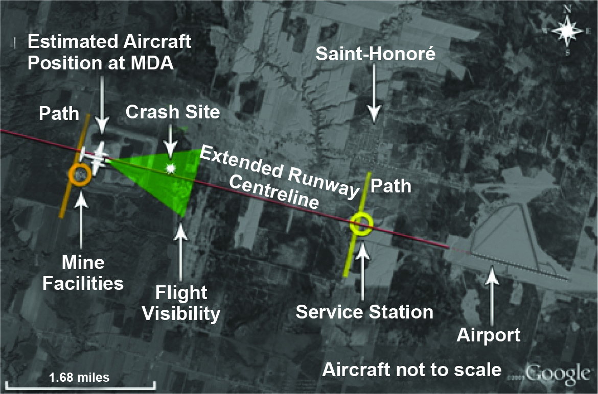
The TSB Laboratory created a composite image of the final approach by superimposing the light sources over a satellite mosaic image (Figure 2). The image shows the estimated position of the aircraft at MDA, relative to the cluster of lights at the mine and the service station.
The black hole effect is an illusion that occurs when an aircraft is on a night approach over unlit terrain. When an aircraft is on approach to a landing area and all is dark below the approach path with only the distant lights providing visual stimuli, an illusory or false sense of height may be perceived. Footnote 38 The pilot believes the aircraft to be higher than it actually is, which then causes the pilot to execute the approach lower than the desired approach path, thereby increasing CFIT risk.
1.10 Instrument Approach Information
1.10.1 General
NAV CANADA responsibilities include providing aeronautical information services (AIS) in Canada to meet the requirements of annexes 4 and 15 to the Convention on International Civil Aviation (Convention). Footnote 39 NAV CANADA is, therefore, responsible for the design, depiction and publication of instrument approach charts in Canada. Other organizations, such as Navtech, Jeppesen and Lido, can also provide aeronautical information services, including instrument approach charts, provided the information has already been distributed by NAV CANADA.
Annex 4 of the Convention describes the specifications for aeronautical charts and constitutes the international standards and recommended practices, which are defined as follows:
- Standard:
“Any specification… the uniform application of which is recognized as necessary for the safety…”
- Recommended Practice:
“Any specification… the uniform application of which is recognized as desirable in the interests of safety…”
1.10.2 Regulatory Overview
TC ensures regulatory overview of activities relating to the provision of aeronautical information services in Canada, including the design and depiction of instrument approaches.
Canada is a member state of ICAO. The CARs Footnote 40 state that aeronautical information services must be in accordance with the standards set out in annexes and 15 of the Convention. However, the CARs do not require compliance with the recommended practices in the Convention annexes.
1.10.3 Instrument Approach Design
Instrument approach procedures in Canada are developed based on a TC manual, entitled Criteria for the Development of Instrument Procedures (TP308/GPH209). According to TP308, “obstacle clearance is the primary safety consideration in the development of instrument procedures.“
TP308 states that the optimum descent path for a non-precision final approach segment is 318 feet per nm, or an angle of 3°, and its use is recommended.
The FAF altitude published in the CAP for the RNAV (GNSS) Runway 12 approach chart at CYRC is 1300 feet asl and this corresponds to a minimum obstacle clearance altitude. Using a height of 46 feet to cross the runway threshold, the resulting descent angle is 1.35°. According to the calculations in TP308 used to determine the FAF crossing altitude on an optimum path of 3°, this would produce an altitude of 2173 feet asl at the FAF. However, this calculated altitude does not appear on the approach charts published in the CAP.
TP308 does not include any specifications for creating tables to cross–check distance versus altitude as presented in altitude/distance tables, to help pilots follow an optimum descent angle of 3° on non-precision approaches. Consequently, no altitude/distance table appears on the CAP approach charts.
1.10.4 Instrument Approach Depiction
The depiction of instrument approaches in the CAP is based on NAV CANADA specifications, which in turn must comply with the standards outlined in Annex 4.
According to the standards in Annex 4, the RNAV (GNSS) Runway 12 approach chart at CYRC, published in the CAP, must indicate the descent angle in the approach profile view. Footnote 41 In 2000, TC issued a finding of non-compliance following an audit of NAV CANADA activities, because the angle of descent did not appear on the approach charts published in the CAP. In 2004, TC issued a reminder because no corrective action had yet been taken. At that point, NAV CANADA asked TC to file a difference with ICAO on this non-compliance with the standard in Annex 4. Consequently, the descent angles are still not indicated on the non precision approach charts published in the CAP.
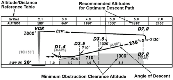
According to the recommended practices in Annex 4, the chart should include a rate of descent table Footnote 42, and the profile view should include a terrain profile or a depiction of minimum altitudes, using either a continuous line to represent the terrain profile or shaded blocks indicating the minimum altitudes of the intermediate or final approach segments Footnote 43 (Appendix C). The RNAV (GNSS) Runway 12 approach chart at CYRC published in CAP does not incorporate, the recommended practices set out in Annex 4 (and is not required to) on the following points:
- The chart does not include a rate of descent table.
- The terrain profile or the shaded blocks indicating minimum altitudes are not depicted.
In December 2009, there were 1339 instrument approaches in Canada, 1217 of which were non–precision approaches (91% of the total).
1.11 Instrument Approach Techniques
1.11.1 General
There are essentially 2 techniques for completing the final descent on a non–precision approach: step–down descent and final descent on a stabilized constant descent angle (SCDA).
1.11.2 Step–down Descent
The step–down descent technique involves flying an aircraft down to the published minimum IFR altitudes or MDA and levelling off. The obstacle clearance may be as low as 250 feet agl. The result is an extended flight at low altitude, waiting either to obtain the visual references needed to continue the descent until the runway or to reach the missed approach point. Consequently, aircraft spend more time than necessary at altitudes that provide a minimum obstacle clearance, thereby increasing the risk of CFIT accidents.
This type of descent increases pilot workload because the successive descents and level-offs require significant changes in attitude and power to maintain a constant speed. The tasks performed while completing these manoeuvres are knowledge–based, Footnote 44 requiring more cognitive effort on the part of the PF and depend on the use of prospective memory. Prospective memory is the memory used to remember that a task must be performed in the near future. Unfortunately, it is known for its limited reliability. Whenever there is a delay between the planning of a task and its execution, such as during periods of heavy workload, or when distractions arise, there is a risk the task will not be completed. Footnote 45 Therefore, to perform tasks that have a significant impact on fight safety, the usual approach is to organize these tasks by means of standardized procedures to avoid depending solely on prospective memory. Footnote 46
In the case of an aircraft equipped with a traditional cockpit, such as C–GPBA, the crew needs to interpret information for the purpose of carrying out and monitoring these manoeuvres. Instruments that are less intuitive to read, and often not as well illuminated as the latest generation of LCD instruments, require an additional cognitive effort.
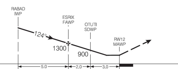
During the RNAV (GNSS) Runway 12 approach at CYRC, the crew used the step-down descent technique (Figure 4). After passing RABAD at 10 nm on final, a rate of descent of approximately 1700 feet per minute was used to reach the CAP-published altitude of 1300 feet asl for the ESRIX FAF. According to the radar data, the aircraft passed ESRIX at 1100 feet, began its descent 0.4 nm past ESRIX with a groundspeed of 100 knots. The initial point of impact with the treetops occurred at an altitude of approximately 500 feet asl, at a distance of 1.6 nm from the last radar position. Based on the last ground speed recorded by radar, it took 58 seconds to cover this distance, which translates into an average rate of descent of 600 feet per minute.
1.11.3 Stabilized Constant Descent Angle
The SCDA technique involves intercepting and maintaining an optimum descent angle of 3° to MDA, which is used as a decision altitude. The descent is therefore flown at a constant angle and constant rate of descent, requiring no configuration change. At MDA, the aircraft does not level off. Therefore, at that moment, either the required visual references are available to continue the approach and land, or a missed approach is initiated. The execution of this type of descent consists primarily of controlling the rate of descent, which calls upon skill-based tasks Footnote 47 and reduces the cognitive effort, consequently the workload. Footnote 48 These tasks associated with an SCDA descent use less prospective memory.
1.11.3.1 Airbus
Airbus technical documentation on non–precision approaches recommends the use of SCDA rather than the classic step-down descent technique, because SCDA results in a stable approach that reduces crew workload during a critical phase of the flight and, therefore, reduces the risks of a CFIT accident.
1.11.3.2 Boeing
According to Boeing, SCDAs can be performed on all non–precision approaches. They can increase safety, prevent CFIT accidents and improve operational capacity. The flight crew training manuals (FCTM) include general information on the use of a constant descent to perform non precision approaches, whereas the various aircraft flight crew operating manuals (FCOM) detail the procedure for performing these approaches on each type of aircraft.
1.11.3.3 National Transportation Safety Board
Following an accident in November 1995 involving a collision with trees on approach, the National Transportation Safety Board (NTSB) issued a recommendation in November 1996 aimed at incorporating a constant angle of descent rather than step–down descents into the U.S. design Standard of the Terminal Instrument Procedures (TERPS) Footnote 49 governing non–precision approaches. In 2008, after several other accidents, the NTSB issued a recommendation to mandate commercial operators to use the SCDA descent technique for non–precision approaches.
1.11.3.4 U.S. Federal Aviation Administration
In 2004, the FAA incorporated a constant angle of descent in about 90 non–precision approaches at airports that serve commercial carriers. The remaining airports were scheduled to have constant angle of descent approach information added by September 2007. Footnote 50 Furthermore, the FAA has endorsed the use of the constant descent angle technique in several publications, Footnote 51 including its Airplane Flying Handbook. Footnote 52 The handbook states, in part, that the SCDA procedure facilitates stabilized descents for non–precision approaches.
In January 2011, the FAA issued a circular Footnote 53 addressing the need to use the SCDA descent technique, along with its advantages, and explained how it could be implemented through SOPs and crew training.
1.11.3.5 Japan
In 2006, Japan introduced the use of constant descent angle profiles with shaded minima for each segment, on its approach charts in compliance with the recommendations of Annex 4.
1.11.3.6 European Union (EU)
In August 2008, the European Commission amended the regulation concerning aerodrome operating minima (EU-OPS1), Footnote 54 which replaced the JAR OPS1 regulation in July 2008. Among other things, this change requires all approaches be flown as stabilized approaches Footnote 55 and that the continuous descent final approach (CDFA) technique, Footnote 56 which is equivalent to SCDA, be used for all standard non–precision approaches. Therefore, all European Union operators were required to use this approach technique by 16 July 2011 at the latest.
According to Jeppesen, an AIS Provider, changes to the design and depiction of instrument approach procedures were completed by 16 July 2011 for most approaches on the territory of the European Union Footnote 57 to be compliant with the new EU–OPS1 standards. As of early 2012, 31 smaller airports still have not had their approach procedures updated to the new design and depiction standard.
The charts produced by Jeppesen incorporate non–precision approach profiles consistent with the standards and recommendations of Annex 4 (Figure 6). These charts will help European Union operators comply with the EU–OPS1 standards by clearly depicting the path to be followed (designed to be 3°). This 3° angle facilitates stabilized descents, similar to precision approaches. The recommended altitudes for flying this descent path, combined with an altitude/distance table and a rate of descent table, make it easier to monitor the descent on approach. Lastly, the shaded blocks indicate minimum obstacle clearance altitudes, providing awareness of the height of the path above terrain.
1.12 Controlled Flight into Terrain
CFIT occurs when an airworthy aircraft under the control of the pilot is inadvertently flown into the ground, water or obstacle. In these occurrences, pilots are unaware of the danger until it is too late. This type of accident often happens when visibility is low, at night or during poor weather. Such conditions reduce a pilot's situational awareness and make it difficult to tell whether the aircraft is too close to the ground.
According to the Flight Safety Foundation (FSF), in the early 1980s, CFIT accidents were the leading cause of aviation fatalities. A task force was created in 1992 with the mandate to reduce the number of CFIT accidents. Spearheaded by the FSF, the task force was set up with over 150 representatives from the airlines, aircraft and equipment manufacturers, as well as technical, research and professional organizations. The task force believed that education and training were easily accessible tools to help prevent CFIT accidents.
In March 2010, the TSB released its Watchlist identifying the safety issues investigated by the TSB that pose the greatest risk to Canadians. In each case, actions taken to date are inadequate and concrete steps must be taken on the part of industry and the regulator to eliminate these risks. One of the safety issues identified in TSB's Watchlist was CFIT accidents.
Counting all types of operations and aircraft, there were 129 CFIT accidents in Canada Footnote 58 and 128 fatalities between 2000 and 2009. CFIT accidents account for 5% of accidents, but nearly 25% of all fatalities. Considering only aircraft registered in Canada for air taxi service, there were 26 CFIT accidents over the same period of time, resulting in 42 fatalities. Furthermore, for air taxi operators, these accidents accounted for 7% of total accidents, but 35% of fatalities during this 10–year period.
1.13 Approach and Landing Accidents
1.13.1 General
A second phase in the CFIT accident reduction program was the creation, in 1996, of the Flight Safety Foundation (FSF) Approach–and–Landing Accident Reduction task force (ALAR) Footnote 59. By focusing on approach and landing, the task force was able to work outside the strict definition of CFIT accidents, which does not include landing short or long, runway overruns, or loss of control following an unstable approach. Therefore, for purposes of clarity and consistency, this report will use “ALA”
to designate approach and landing accidents, including CFIT accidents on approach.
In 1998, the FSF task force issued the following recommendations targeting the reduction and prevention of the ALA accidents.
1.13.2 Recommendations Concerning Company Policies
- Operators should specify well–defined Footnote 60 approach gates.
- Operators should define the parameters of a stabilized approach in their company flight operations manuals (FOM) and aircraft operating manuals (AOM).
- The stabilized approach policy should at least cover the flight path, speed, power setting, altitude and rate of descent, as well as configuration and flight crew landing readiness.
- All flights should be stabilized by 1000 feet agl in instrument meteorological conditions (IMC) and by 500 feet agl in visual meteorological conditions (VMC).
- Operators should develop and support
“no–fault“
go–around and missed approach policies. - FOMs or SOPs should require a go–around if an aircraft becomes unstable during approach.
- Operators should implement SCDA procedures for non–precision approaches.
- Operators should develop and implement a policy on appropriate autopilot use in conditions of reduced visibility, at night or in the presence of optical or physiological illusions.
- Operators should establish clear directives for TAWS alerts.
1.13.3 Recommendations Concerning SOPs
- States should mandate, and operators should develop and implement, SOPs for approach–and–landing operations.
- States should mandate the use of SOPs for approach–and–landing operations.
- Operators should develop SOPs for autopilot use during approaches and landings.
- Operators should have a clear policy on the role of the pilot–in–command in complex situations and train accordingly.
- A risk assessment checklist should be used to identify approach and landing hazards.
1.13.4 Recommendations Concerning Training
- Crews should be trained to identify operational risks associated with adverse conditions, such as reduced visibility, visual illusions, contaminated runways and cross winds.
- The training should deal with non precision approaches, especially those that involve shallow approach paths or stepped descents.
- Crews should be trained to take the time to implement corrective actions when the cockpit situation becomes confusing, ambiguous or task saturated.
- Operators should develop and implement a policy on appropriate autopilot use along with navigation aids for the approaches being flown.
- Crews should receive training on SCDA approach procedures.
- Crews should be educated about approach design criteria and minimum obstacle clearance requirements.
1.13.5 Recommendations Concerning Decision Making
- Operators should provide education and training that enhance decision making and risk (error) management.
- Operators should develop a decision–making model for use in time–critical situations (where the time available for decision making is limited).
- Provide improved training on error management and risk assessment as well as on mitigating the consequences of errors.
1.13.6 Recommendations Concerning CVRs and FDRs
- Regulatory authorities should encourage the installation of FDRs and CVRs on aircraft for which they are currently not required.
1.13.7 Recommendations Concerning Autopilot
- The FSF task force recommended that the autopilot be used, especially in conditions of reduced visibility, at night or in the presence of optical or physiological illusions.
1.13.8 Recommendations Concerning Radio Altimeter
- Operators should state that the radio altimeter is to be used during approach operations and specify procedures for its use.
- Train crews to correct the radio altimeter bug to 200 feet agl on all approaches except for CAT II and III.
- Train crews to initiate an aggressive go–around if the alarm sounds without visual contact being established with the runway.
- Operators should activate automatic callouts or require callouts from their crews, at 2500, 1000 and 500 feet agl as well as at the minimums.
Other than Exact Air's publication of an SOP and the provision of training for takeoffs and landings in cross–winds and on contaminated runways, none of the other FSF task force recommendations had been implemented at the time of the occurrence. It should be noted that most air taxi operators do not implement these recommendations, nor are they required to do so by regulation.
1.13.9 Recommendations Concerning Instrument Approach Procedure Design
- Non–precision approach procedures should be constructed, whenever possible, in accordance with established stabilized approach criteria.
- The final approach glide path should be a nominal 3° where terrain permits.
- A continuous descent is preferred to a stepped approach.
1.13.10 Recommendations Concerning the Depiction of Instrument Approach Charts
- Non–precision approach charts should show the descent profile to be flown instead of the minimum obstacle clearance altitudes.
None of the FSF task force recommendations concerning the design and depiction of instrument approaches was incorporated into the RNAV (GNSS) Runway 12 approach at CYRC published in the CAP (Appendix A), nor are they required by regulation.
1.13.11 Recommendations Concerning the SCDA Approach Technique
- Implement use of SCDA procedure for non–precision approaches.
- Crews should receive training on SCDA approach procedures.
- Crews should be educated on approach design criteria and minimum obstacle clearance requirements.
The FSF task force found that the accident risk during a non–precision approach was 5 times greater than during a precision approach and it recognized the need for stabilized approaches. However, the stabilized approach is not formally used by air taxi operators in Canada, nor is it required by regulation.
1.13.12 FSF ALAR Tool Kit
Further to the recommendations of the FSF task force, an ALAR tool kit was developed and distributed by the FSF as a resource that could be modified as required and used for training pilots, air traffic controllers and managers. The tool kit contains the report of the ALAR task force, conclusions and recommendations, videos, presentations, hazard checklists, documentary notes and, lastly, other products designed to prevent approach and landing accidents.
The International Air Transport Association (IATA) has endorsed the FSF ALAR Tool Kit and has recommended that its members use it. In 2001, ICAO stated that the ALAR Tool Kit contained extremely valid accident prevention information and that member states should consider incorporating the material into their training programs. ICAO then purchased and distributed 10 000 copies of the tool kit at its 33rd Assembly in the fall of 2001. To date, approximately 40 000 copies of the tool kit have been distributed worldwide. At the time of the accident, Exact Air Inc., like the majority of air taxi operators, was unaware of the existence of the FSF ALAR Tool Kit.
1.13.13 Other Approach and Landing Accident Reduction Initiatives
Among the teams mandated by the FAA were the GA CFIT Joint Safety Analysis Team (JSAT), which was asked to study CFIT accidents, and the CFIT Joint Safety Implementation Team (JSIT), charged with implementing the intervention strategies proposed by JSAT. In March 2003, the FAA released a study on general aviation CFIT accidents Footnote 61 that validated the efforts of JSAT and JSIT.
The National Lucht–en Ruimtevaartlaboratorium in the Netherlands published a CFIT report in 1997, Footnote 62 which stated that 70% of CFIT accidents occurred during approach and landing, and further that 95% of these accidents involved regional carriers. Among other things, the report recommended the installation of ground proximity warning devices and use of the FSF Tool Kit.
In 2007, the ATSB published a research and analysis report on CFIT accidents in Australia. Footnote 63 It concluded that, despite international efforts, CFITs continued to be a challenge. In addition, the report stated that a sustained effort was justified to reduce the risk of CFIT accidents, given the strong likelihood of such occurrences resulting in loss of life.
In 1998, TC published an article titled "CFIT — Why Are Aircraft Flying at Minimum IFR Altitudes?" Footnote 64 After reviewing the FSF Tool Kit, the author emphasized that the kit should be “required reading for ALL pilots who are currently flying in the world's skies”
. The article acknowledged that most CFIT events occurred on non–precision approaches and while discussing minimum IFR altitudes on approach he asks, “why are you there ?”
. The answer can be found in part within the same article — “because that's what is published.”
The article then reminds pilots that the altitudes published on instrument approach charts are minimum obstacle clearances altitudes and not necessarily target altitudes. TC reprinted the same article in the first 2011 issue of the Aviation Safety Letter, pointing out that it is still relevant 13 years later.
In 1999, TC published an Air Carrier Advisory Circular (ACAC) Footnote 65 intended to bring to the attention of air carriers the soon to be implemented CARs requirements for mandatory training for CFIT accident avoidance. The circular cited the FSF Tool Kit as a reference and encouraged carriers to use it in developing adequate CFIT training.
In September 2006, TC published a Commercial and Business Aviation Advisory Circular (CBAAC) pertaining to changes to the Approach Ban that were to come into force on 01 December 2006. Footnote 66 The CBAAC was aimed primarily at commercial operators governed by sections 703, 704 and 705 of the CARs and who wanted to benefit from reduced approach ban visibility values. The CBAAC acknowledged the work done by the FSF task force and the need to carefully control an aircraft's vertical position on approach. The risks associated with step–down descents were explained and the SCDA technique introduced as a way to prevent CFIT accidents.
However, neither the Instrument Procedures Manual (TP2076) nor the Aeronautical Information Manual (TP14371) published by TC explains the use of the SCDA technique. NAV CANADA does not distribute information on this technique, since the approaches published in the CAP are not designed based on SCDA descents. In addition, even if pilots wanted to use this technique, the instrument approach charts published in the CAP do not display the optimum 3° decent path to be flown.
None of the pilots interviewed during this investigation were familiar with the SCDA technique.
1.13.14 Approach and Landing Accidents in Canada
According to data compiled by the TSB, the ALA rate for commercial operations seems to have generally decreased only slightly over the past decade whereas the number of fatalities has remained constant. Between 2000 and 2009, ALAs accounted for 62% of all accidents involving air taxi services in Canada. Footnote 67 The number of accidents involving air taxi operations is still considerably higher than the number of accidents for airline and commuter operations, accounting for approximately 70% of all commercial operation ALAs. The result is that, on average, there are 12 times more ALAs in air taxi service than in airline operations.
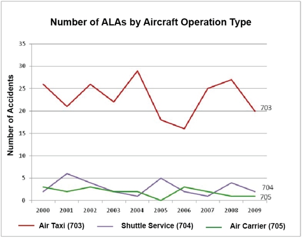
Approximately 80% of commercial operation ALAs have taken place at airports that are only equipped with non–precision instrument approaches. Regional airports, which are rarely equipped for precision instrument approaches, are generally those used by air taxi operators.
Between 2008 and 2009, including this accident, the following ALAs and occurrences were investigated by the TSB Footnote 68 and all occurred following a non–precision approach:
- A Dornier 228 collided with the ground 1.5 nm before the runway threshold, on 13 December 2008;
- A Boeing 727 struck some trees 2.7 nm before the runway threshold, on 19 February 2008;
- A DH8 overran the runway on 14 December 2008;
- A BE10 struck some trees 2.5 nm before the runway threshold, on 16 January 2009;
- A BE10 struck some trees 3.0 nm before the runway threshold, on 09 December 2009.
Following these investigations, the TSB reports noted in several instances the importance of the FSF ALAR task force's recommendations in reducing the risks of ALA accidents.
1.14 ICAO Risk Assessment Matrix
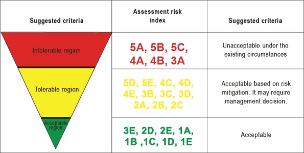
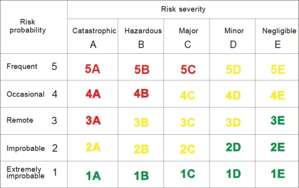
ICAO defines risk as “the assessment, expressed in terms of predicted probability and severity, of the consequences of a hazard, taking as reference the worst foreseeable situation.”
Footnote 69 When the probability is considered to be remote and the severity, catastrophic, ICAO's risk tolerability matrix (Appendix D) shows that the risk is unacceptable and strategies to control or mitigate the risks must be put in place.
The following TSB laboratory reports were completed:
- LP172/2009 – Continuity Determination
- LP174/2009 – Instrument Examination
- LP175/2009 – Engine Examination
- LP021/2010 – Sound Analysis
- LP042/2010 – Investigation Diagrams
- LP064/2010 – Seat Examination
- LP180/2010 – ELT Examination
These reports are available from the Transportation Safety Board of Canada upon request.
2.0 Analysis
The crew performed a non–precision approach at night in adverse weather conditions. The aircraft was in controlled flight when it descended below MDA and struck treetops 3 nautical miles (nm) from the runway threshold. A detailed examination of the wreckage and its components did not indicate any failure that contributed to the accident.
Consequently, the analysis will focus initially on the circumstances of the flight and the factors that could have led the pilots to descend prematurely below MDA, apparently without realizing the proximity of the terrain. The analysis will then look at Approach and Landing Accident (ALA) risks along with proven mitigation strategies.
2.1 The Flight
Before taking off from Val–d'Or (CYVO), the crew was aware of the forecast conditions at Bagotville (CYBG). These conditions did not meet CARs requirements for an alternate airport. Given that no METAR was available for CYRC airport, the crew could not know the prevailing conditions at the destination. However, given the proximity of CYBG airport to CYRC, the crew could have expected similar conditions. Moreover, given the adverse weather conditions at the destination airport, it was important that the selected alternate airport provide an alternative landing option in the event of a diversion. Nevertheless, the crew did not change the designated alternate airport on the flight plan despite having sufficient fuel for 1 hour and 52 minutes of extra flight time. As the flight is operated under a self–dispatch operational control system, the captain is solely responsible for filing the operational flight plan, which includes the alternate airport selection.
During the flight, the crew tried to obtain the latest runway conditions from the Québec City FIC; but, because the CYRC tower was closed, the information was not available. Millions of landings take place every year on runways in Canada. Rain, snow, ice and melting snow can contaminate runways and have an impact on the landing distance. Pilots must calculate the landing distance before each attempt. To this end, they require accurate information on the condition of the runway surface. If such information is not available, the landing distance could be miscalculated and a runway excursion could occur.
Before attempting the approach and landing at CYRC, the PNF should have indicated the crew's intention on the ATF frequency at least 5 minutes before initiating the approach. Position reports were required at RABAD and then at the FAF. However, only one call was made from C–GPBA, just before crossing the FAF. Omitting to report an aircraft's position is a recurring phenomenon. However, it is essential for flight safety in uncontrolled airspace that pilots follow established procedures to avoid conflicts with other aircraft and vehicles on the ground.
The Canadian Mission Control Centre (CMCC) in Trenton was advised that C–GPBA's ELT had activated, but the Canadian Beacon Registry did not have any owner information in case of an emergency. Because this was a commercial operator, additional research made it possible to locate the company's managers. In other circumstances, however, the delay could be longer and have serious repercussions for survivors. Consequently, it is essential that ELTs also be registered with the Canadian Beacon Registry so that the owner or operator of an aircraft can be quickly contacted.
Cell phones are ubiquitous and are more and more used to report accidents. During search and rescue efforts, the location of the passenger's call to 911 emergency services was established 5 nm to the southeast of the accident site. This position gap increased search time, which increased the risk of additional suffering and loss of life.
2.2 Descent below MDA
2.2.1 General
The copilot was the pilot flying (PF) and in preparing for the approach should normally have completed an approach briefing as per SOPs, which includes a briefing on the approach chart and published minimum altitudes. Normally, a crew would apply an altimeter correction for low temperature to the CAP published altitudes.
As the aircraft was flying at a higher altitude and speed than normal on its initial approach, it is possible that the crew's workload was high at the beginning of the approach. The aircraft intercepted the final approach course at 3900 feet asl with a ground speed of 200 knots. A rate of descent of approximately 1700 feet per minute was used to reach the CAP published altitude of 1300 feet asl before crossing the FAF.
The crew made its first call on the ATF frequency just before crossing the FAF, but indicated that it was approaching RABAD instead of the ESRIX FAF. Omission of the other required calls and the position error may have been caused by the crew's heavy workload.
Based on the radar data, the aircraft crossed the FAF at 1100 feet asl, 200 feet below the published altitude. The crew would normally have applied the altimeter correction of 67 feet for low temperature and the correction of 30 feet for use of the CYBG altimeter setting to ensure they would cross the FAF at 1300 feet asl. These altimeter corrections are important because the crew was targeting the CAP published altitude, which is, in fact, a minimum obstacle clearance altitude. When an aircraft descends below the published altitude, safety margins are reduced and the aircraft is at risk of a CFIT accident.
Because the step–down descent technique was used, the PF needed to manoeuvre the aircraft to reach the FAF at the CAP published altitude of 1300 feet asl (corrected to 1397 feet asl), with flaps in the approach position and the landing gear down, maintaining an indicated approach speed of approximately 130 knots. After crossing the FAF, the PF was to descend and maintain an altitude of 900 feet asl (altitude corrected to 970 feet asl) until the OTUTI step–down fix, then descend to the MDA of 860 feet asl (corrected to 920 feet asl).
The step–down descent placed the aircraft at the MDA at a distance of approximately 4 nm from the runway threshold. Consequently, the PF had to stop the descent and maintain MDA until the required visual references could be acquired, before continuing the descent to the runway. To follow an optimum 3° path from MDA to the runway, the descent needed to be initiated less than 1 nm from the runway threshold. Therefore, the aircraft had to remain level at MDA for approximately 3 nm, which at a ground speed of 100 knots would take 1 minute and 48 seconds.
When the aircraft left radar coverage at 1100 feet asl, its location was 0.5 nm past the FAF. Once the descent was initiated, the PNF had to call out “100 to go”
and the PF had to stop the descent at 970 feet asl, which corresponds to a height of approximately 450 feet agl. Based on an elapsed time of 57 seconds between the last radar position and the point of impact with the treetops, the average rate of descent was 600 feet per minute. This would mean the crew used the usual rate of descent to reach the MDA, without levelling off at minimums.
In the absence of a CVR, it was not possible to determine:
- The events in the cockpit during the approach
- The crew's workload
- The CRM's effectiveness
- Whether the altimeter corrections for low temperature and remote altimeter setting were calculated and applied
- Whether the checklist was completed
- The reason why the aircraft descended below the published FAF crossing altitude followed by the descent below the MDA
TC's intent is to ensure that a CVR be installed when a multi–engine turbine–powered aircraft has 6 or more seats and 2 pilots are required either by the aircraft type certificate or by the subpart under which the aircraft is operated. Following the judgment of the Federal Court of Appeal, TC is still in the process of clarifying the requirement for a CVR in 2 pilot operations.
2.2.2 Factors, Influences and Scenarios
2.2.2.1 Autopilot
The use of an autopilot is recommended by several organizations as a way to reduce pilots' workload so they can better concentrate on acquiring the required visual references necessary before continuing the descent below MDA. C–GPBA's autopilot was not working. Even when working, however, the autopilot is generally not used by BE10s on final approach because the means for controlling the descent are limited.
2.2.2.2 Terrain Awareness Warning System (TAWS)
C–GPBA was normally based at CYRC and was the company's only BE10 not fitted with TAWS.
The presence of TAWS on board aircraft provides pilots with an added sense of safety and they become accustomed to it with the occasional terrain proximity warnings that appear on approach. As the occurrence aircraft descended below 300 feet agl at a distance between 3 and 4 nm from the runway, a TAWS equipped aircraft would have provided the crew with a premature descent alerting amber caution alert, with the associated “Too Low Terrain”
aural message.
Additionally, when the predicted impact with the terrain was within 30 seconds, an amber caution alert with the associated “Caution Terrain; Caution Terrain”
aural message would have been generated. Finally, when within 15 seconds of impact, a red warning alert with the associated “Terrain, Terrain; Pull Up, Pull Up”
aural message would have been provided to the crew.
Because the crew was based at Baie–Comeau and flew almost exclusively on the BE10s equipped with TAWS, the pilots may have forgotten that C–GPBA was not equipped with one. Given their workload on approach, it is possible that the pilots expected that, were the aircraft too near the ground, the TAWS warning would have sounded. Footnote 70
The TSB has investigated numerous collisions with land and water and has identified deficiencies, made findings and issued recommendations, such as installing ground proximity warning systems. Although some action has been taken, more needs to be done. Wider use of technology is needed to help pilots assess their proximity to terrain.
In 2012, the CARs still do not require installation of ground proximity warning devices on aircraft operating in commercial air taxi service.
2.2.2.3 Altimeters
The fact that the radar recorded the aircraft at appropriate altitudes throughout the flight would seem to indicate that the altimeters were working properly. However, because the 2 barometric altimeters were not equipped with a target altitude bug, the crew had to rely on their prospective memory when it came time to level off at MDA.
The radio altimeter decision height bug was set at approximately 1500 feet (agl). Given that the ground in this area is at approximately 450 feet asl, the “DH”
light illuminated when the aircraft descended below 1950 feet asl. At that moment, the aircraft was 2.6 nm before ESRIX, i.e., 7.6 nm from the threshold of Runway 12.
This reminder probably would not have elicited a response from the crew as it wasn't linked to an approach altitude. Moreover, an adjusted setting above 1000 feet agl makes detecting ground proximity more difficult because of the calculations and interpretation required.
The FSF recommends setting the decision height bug at 200 feet agl on non–precision approaches as a means of increasing awareness on the part of crews to the proximity of the ground. At a normal rate of descent of 600 feet per minute, the “DH”
light will illuminate about 20 seconds before impact with the ground. As, at this height, an aircraft on a 3° path should be at a distance of 0.6 nm from the runway threshold, the runway should be in sight directly in front of the aircraft.
Using this recommended procedure, it is possible to initiate an immediate go around without calculations or interpretations when the “DH”
light illuminates and the runway is not in sight.
As the CARs do not require use of a radio altimeter for non-precision approaches, and the FSF recommendations regarding radio altimeters are not known or implemented, this additional defence against ALAs was not used.
2.2.2.4 Distraction Caused by an Emergency or Abnormal Situation
The annunciator panel lights were examined at the TSB Laboratory and it was determined that the left and right generator lights were on, as was the fault warning light. No fault warning alarm was noticed from the passenger cabin before the impact with the trees. As the aircraft traveled a distance of approximately 600 feet through the trees and the wings were severed before impact with the ground, it is reasonable to assume that the generators stopped working as a result of the collision with the trees. Consequently, it is unlikely that the descent below MDA was caused by a significant distraction related to a major electrical failure or the illumination of the fault warning.
2.2.2.5 Intentional Descent Without Visual References
It is unlikely that the crew chose deliberately to descend below MDA without having first acquired visual references, since the base of the cloud layer in the area was at 4200 feet agl . The aircraft reached MDA at a distance of approximately 4 nm from the runway threshold, with ground visibility at one nm. There was no advantage, therefore, to descending even lower, since the approach lights, at that distance, would not be any more visible.
2.2.2.6 Possible Scenarios
As the aircraft approached MDA, the PNF would normally have called out “100 to go”
and, while monitoring the approach, performed a visual scan outside to acquire visual references. During this time, the PF would be focused exclusively on his instruments to begin levelling off the aircraft at the MDA and maintaining this altitude. The PF would then wait for the PNF's callout (“Altitude Contact”
; “No Contact”
; “Approach Lights”
; or “Runway in Sight”
) before shifting some of his attention outside to acquire the visual references.
The investigation determine that there was probably no levelling–off at MDA and no significant distraction at this stage of the approach. It follows that the PF's attention must have shifted outside at the time when the level–off to MDA should have been performed. In this context, 2 plausible scenarios remain:
- Both pilots were looking outside in the hope of acquiring visual references because they believed that the runway was close in front; or
- The pilots saw lights in the distance, which induced them to focus their attention outside in order to continue the approach.
Pilots who regularly use the approach to Runway 12 at CYRC know that, once they pass the service station lights, the runway is imminent. However, the intensity of the lighting at the mine had increased considerably since the PF had received professional training at CYRC. It was therefore possible to confuse the mine for the service station. The composite image created following the test flights shows that the distance between the mine lights on approach and the accident site is approximately the same as the distance between the service station and the threshold of Runway 12 (Figure 2).
The aircraft reached MDA just after passing the mine lights. It is conceivable that, as they were passing, the pilots confused the mine lights for the service station lights located one nm from the runway threshold. Consequently, it is plausible that, as they were levelling off at MDA, the 2 pilots focused their attention outside the aircraft in an effort to see the approach lights.
The investigation confirmed that the ARCAL system had not been activated before the accident. Therefore, the approach, runway and airport lights were not illuminated when the aircraft descended below MDA. However, it is possible that the service station lights were visible from a distance when the aircraft reached MDA, since flight visibility can vary considerably from region to region in snow shower conditions. This is particularly true at night when flight visibility can be up to twice the visibility on the ground if lights are being observed.
The test flights revealed that the accident site was located in an area of the approach devoid of lights. The crew was, therefore, flying over unlit terrain with the service station lights possibly visible in the distance. The PNF would normally have called the lights in sight and it is probable that the PF shifted his focus outside to see them. Consequently, it is possible that both pilots were victims of a black hole illusion. In such conditions, it would be difficult to correctly estimate height because the pilots would feel that they were higher than was actually the case and would have believed they were on an acceptable approach path until the initial contact with the treetops.
Given the number of hours spent performing tasks related to driving a car and flying an aircraft in conditions requiring heightened visual focus, it is possible the crew was experiencing task induced fatigue. Given that such fatigue has a negative effect on visual and cognitive performances, it is possible that the ability to concentrate, operational memory, perception and visual acuity were all diminished. The effects of the task–induced fatigue possibly increased the difficulty in acquiring and subsequently interpreting the visual references required to safely continue the descent below MDA.
2.3 Risk Assessment and Mitigation of Non–precision Approaches
Air taxi operators generally serve regional airports that, in most cases, are only equipped with non–precision approach capabilities. The 1217 non–precision approaches in Canada account for 91% of all the CAP–published approaches. The FSF ALAR task force determined that the risk of ALAs was 5 times higher for non–precision approaches than precision approaches. In addition, the majority of accidents involving air taxi operations are ALAs, which account for 70% of all commercial operation ALAs.
As CFIT accidents cause significant damage and generally result in loss of life, based on the ICAO definition, the severity of such an occurrence is considered catastrophic.
TSB data indicate that there were 230 ALA accidents involving air taxi operations over the past decade–on average 12 times more than were sustained by airline operations. It is reasonable to conclude that other ALA accidents are likely to occur; therefore, the probability of an ALA occurring is either occasional Footnote 71 or remote. Footnote 72
The risk is defined based on a prediction of probability and the severity of consequences. It is not possible to reduce the catastrophic consequences of a collision with the ground, and the probability of an ALA occurring is real. In these conditions, ICAO's risk tolerability matrix indicates that strategies to control or mitigate the risks must be put in place so that the risks can be reduced to as low as reasonably practicable for non-precision approaches.
This ALA risk is known and documented and there are formal evaluation and prevention tools to address it.
2.4 ALA Risk Mitigation Actions
2.4.1 General
In an effort to reduce ALA accidents, several ICAO member states, including all the countries in the European Union, have chosen to implement the actions recommended by the FSF ALAR task force, along with the recommendations in Annex 4 for improving the visual aspect of charts used in connection with non–precision instrument approaches.
2.4.2 Instrument Approach Design
According to the CARs, the design of the RNAV (GNSS) Runway 12 approach at CYRC is compliant with the TP308 standards. However, by focusing primarily on obstacle clearance for the design of instrument procedures, international efforts to reduce ALAs, including the final approach based on an optimum descent path of 3°, are not taken into consideration.
As a result, the RNAV (GNSS) Runway 12 approach at CYRC, which does not include any significant obstacles on approach, was designed with a FAF crossing altitude of 763 feet above the runway threshold at a distance of 5 nm. As this is the only altitude for crossing the FAF published in CAP, pilots generally use it as a target. In these circumstances, the descent angle is only 1.35°.
In 1998, TC published an article on CFIT that asked the question: Why are aircraft flying at minimum IFR altitudes on non-precision approaches? The article examines the role of pilots and not systemic aspects that may affect their performance. According to Dekker's perspective on human error Footnote 73 , blaming an individual rather than trying to understand a situation from the individual's standpoint avoids identifying and solving the real problems.
The same article was reprinted 13 years later, with an acknowledgement that the problem continues to exist in 2011. According to Hollnagel Footnote 74, it is recognized from an accident prevention standpoint that a reminder to be careful when facing certain risks is not an efficient safety strategy. The risk needs to be counteracted by restructuring or by introducing safety measures aimed at protecting the individual against such a risk.
According to data compiled by the TSB, the ALA rate for commercial operations seems to have generally decreased very little over the past 10 years. It would appear, therefore, that the strategy employed by TC has not been effective.
2.4.3 Instrument Approach Depiction
The RNAV (GNSS) approach chart for Runway 12 at CYRC published in the CAP does not meet all the depiction standards outlined in Annex 4, since the descent angle does not appear on the charts. Consequently, pilots flying non-precision approaches in Canada do not benefit from a visual reminder, indicating for this particular approach, that if it is flown at the published altitudes, the descent angle is only 1.35° instead of the recommended optimum 3°.
The RNAV (GNSS) approach chart for Runway 12 at CYRC published in the CAP does not incorporate all of the depiction recommended practices in Annex 4, and TC does not require compliance with them. Consequently, the approach charts published in the CAP exclude the visual aspects recognized for their beneficial effects on positional awareness relative to terrain, such as:
- Angle of descent
- Depiction of the optimum descent path
- Altitude/distance table
- Profile of terrain below the approach
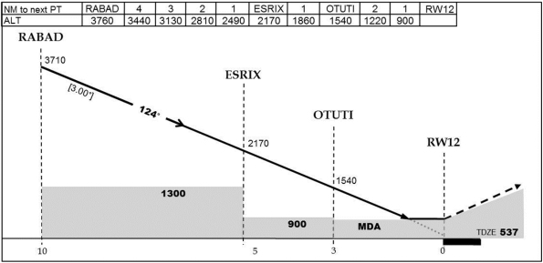
The only line with an arrow appearing on the RNAV (GNSS) approach chart profile for Runway 12 shows what appears to be the course to be flown (Figure 8). According to the designers, these altitudes are obstacle clearance minimums and pilots should not necessarily follow them. In 1998 and again in 2011, articles published by TC asked why pilots fly at these altitudes. However, no other options are indicated on the chart and TC does not publish formal reference documents to explain instrument flight procedures in Canada.
The descent profile is not shown to scale. Consequently, the horizontal distance to descend 400 feet between ESRIX and OTUTI is almost the same as to descend 40 feet after OTUTI to the MDA. Visually, this similarity in horizontal distance could create a false perception of the time required to descend to the MDA after OTUTI, and could mask the fact that the angle of descent is 1.35° instead of the recommended 3° optimum path.
Using an altitude/distance table is cognitively easier when executing and monitoring a descent on final, since the calculations are already made and it is simply a matter of comparing the altitudes and distances. Given the possibility that the crew was experiencing task–induced fatigue, which has a negative effect on the operational memory used for mental calculations, the use of such a table would reduce the risk of error when performing the descent.
Approach charts published in the CAP do not include terrain profiles. A pilot must, therefore, develop knowledge of the height above the terrain by means of deduction, which, in and of itself, requires greater cognitive effort than if the terrain were shown visually on the charts.
The instrument approach charts that incorporate the recommendations of Annex 4 provide a precise visual image of the path to be followed, while indicating the minimum obstacle clearance altitudes. These visual elements, which are recognized for their beneficial effects on positional awareness relative to terrain, reduce the required cognitive effort and, by extension, workload when flying an approach.
2.4.4 Stabilized Constant Descent Angle Technique
The step–down descent relies on prospective memory, which requires a heavier workload and more cognitive effort than a SCDA descent. Consequently, one one hand, depending on whether a crew is tired or not, it is more vulnerable to making errors inherent to the execution of the step-down approach. The task simplification associated with the SCDA technique, on the other hand, enables the cognitive effort required for the approach to be reduced, thereby reducing the workload and, by extension, the risk of error.
The benefits of the SCDA technique have been demonstrated and validated by TC and several international organizations. The use of the SCDA technique is mandatory for a number of commercial operators in various countries, including all operators in the European Union as of 16 July 2011. However, the vast majority of air taxi operators in Canada do not use the SCDA technique for non precision approaches.
Following the release of Commercial and Business Aviation Advisory Circular No. 238 in 2006, adoption of the SCDA descent technique has often been confused with the need to use it to benefit from the approach ban operations specification. TC approval is necessary to obtain operations specification. Consequently, a number of pilots believe, wrongly, that they cannot perform a SCDA descent without TC's prior approval.
The Instrument Procedures Manual (TP2076) did not cover the SCDA technique and, in 2010, TC decided to cease its publication. As a result, Canadian pilots must obtain technical information on SCDA approaches elsewhere. By using reference documents not based on Canadian approach design and depiction standards, pilots could possibly experiment with techniques that are not adapted to the information appearing on CAP published approach charts.
2.4.5 FSF Recommendations
The recommendations of the FSF ALAR task force have been recognized internationally as tools for mitigating the risks of approach and landing accidents. These recommendations cover all operational aspects, from the design and depiction of instrument approaches to company policies, SOPs, training and equipment on board aircraft.
Several of these recommendations touch upon relatively simple ways to reduce operational irregularities by clarifying company policies, such as including a precise definition of the stabilized approaches to be used and a go-around policy, without risk of reprimand. Other recommendations concern pilots, focusing on the role of the pilot in command in complex situations, the use of decision-making models, threat and error management, SOPs and training.
With respect to the occurrence flight, C–GPBA was equipped with a radio altimeter. However, the target altitude bug was set to 1500 feet agl , and therefore its light went on at 1500 feet agl. According to the task force's recommendations, the radio altimeter should be set to 200 feet agl for this type of approach and the crew should be trained to perform an aggressive go–around if the radio altimeter light comes on without visual contact with the runway. In several of the plausible scenarios that were considered, this action alone might have avoided the impact with the trees.
The company, like many air taxi operators, was unaware of the FSF ALAR task force recommendations. The company had implemented what was required by the CARs, which only capture a few of the FSF ALAR task force recommendations.
2.4.6 FSF ALAR Task Force Tool Kit
IATA and ICAO both endorsed the FSF ALAR toolkit as a valuable aid for ALA prevention and recommended that this material be incorporated into training programs. ICAO then distributed 10 000 copies of the tool kit. Over 40 000 copies in total have been distributed around the world. Unfortunately, none of the operators or pilots interviewed as part of this investigation were familiar with the tool kit. Several of the measures cited in it are therefore not used in Canada, thus exposing crews and passengers to a higher ALA risk.
The crew of C–GPBA did not have at its disposal the ALA risk mitigation tools that are available around the world. The environment in which they conducted the approach was performed without the benefit of the defences within the ALAR toolkit. The pilots flew at the CAP published altitudes to perform the RNAV (GNSS) Runway 12 approach, doing so on the basis of their training and practices and because these were the only altitudes appearing on the chart. After crossing the FAF, the crew used the usual rate of descent corresponding to a 3° path. The aircraft found itself at the minima at 350 feet agl and 4 nm from the runway threshold, over an area without lights that is subject to a black hole illusion.
The company's operations manual, SOPs, training, C–GPBA equipment and approach charts all complied with the CARs. The aircraft, not having levelled off at the minima, struck the trees 3 nm before the runway threshold. Therefore, this accident, in addition to other ALAs that have occurred in similar circumstances over the past few years, would seem to indicate that the measures in place for mitigating this accident risk are inadequate.
3.0 Conclusions
3.1 Findings as to Causes and Contributing Factors
- For undetermined reasons, the crew continued its descent prematurely below the published approach minima, leading to a controlled flight into terrain (CFIT).
3.2 Findings as to Risk
- The use of the step-down descent technique rather than the stabilized constant descent angle (SCDA) technique for non-precision instrument approaches increases the risk of an approach and landing accident (ALA).
- The depiction of the RNAV (GNSS) Runway 12 approach published in the Canada Air Pilot (CAP) does not incorporate recognized visual elements for reducing ALAs, as recommended in Annex 4 to the Convention, thereby reducing awareness of the terrain.
- The installation of a terrain awareness warning system (TAWS) is not yet a requirement under the Canadian Aviation Regulations (CARs) for air taxi operators. Until the changes to regulations are put into effect, an important defense against ALAs is not available.
- Most air taxi operators are unaware of and have not implemented the FSF ALAR task force recommendations, which increases the risk of a CFIT accident.
- Approach design based primarily on obstacle clearance instead of the 3° optimum angle increases the risk of ALAs.
- The lack of information on the SCDA technique in Transport Canada reference manuals means that crews are unfamiliar with this technique, thereby increasing the risk of ALAs.
- Use of the step–down descent technique prolongs the time spent at minimum altitude, thereby increasing the risk of ALAs.
- Pilots are not sufficiently educated on instrument approach procedure design criteria. Consequently, they tend to use the CAP published altitudes as targets, and place the aircraft at low altitude prematurely, thereby increasing the risk of an ALA.
- Where pilots do not have up-to-date information on runway conditions needed to check runway contamination and landing distance performance, there is an increased risk of landing accidents.
- Non–compliance with instrument flight rules (IFR) reporting procedures at uncontrolled airports increases the risk of collision with other aircraft or vehicles.
- If altimeter corrections for low temperature and remote altimeter settings are not accurately applied, obstacle clearance will be reduced, thereby increasing the CFIT risk.
- When cockpit recordings are not available to an investigation, this may preclude the identification and communication of safety deficiencies to advance transportation safety.
- Task–induced fatigue has a negative effect on visual and cognitive performance which can diminish the ability to concentrate, operational memory, perception and visual acuity.
- Where an emergency locator transmitter (ELT) is not registered with the Canadian Beacon Registry, the time needed to contact the owner or operator is increased which could affect occupant rescue and survival.
- If the tracking of a call to 911 emergency services from a cell phone is not accurate, search and rescue efforts may be misdirected or delayed which could affect occupant rescue and survival.
3.3 Other Findings
- Weather conditions at the alternate airport did not meet CARs requirements, thereby reducing the probability of a successful approach and landing at the alternate airport if a diversion became necessary.
- Following the accident, none of the aircraft exits were usable.
4.0 Safety Action
4.1 Action Taken
4.1.1 Exact Air Inc.
To minimize the risks of Approach and Landing Accidents (ALA), the company implemented stabilized constant descent angle (SCDA) in its SOPs.
A program was set up to progressively install radio altimeters on the company aircraft.
The company controlled flight into terrain (CFIT) training was reviewed to integrate the recommendations of the flight safety foundation ALAR task force.
The following measures have been, or will be taken by Exact Air Inc. to reduce the operational risks:
- The review of all departments related to flight operations.
- A complete review of standard operating procedures (BE10, PA–31, PA–34, C–402).
- A review of operational limitations of the charter operations (ie: new restrictions for new captains and first officers as well as equipment restrictions).
- All flying personnel will redo the company CFIT course.
- A risk analysis file is available to the flight crew to review level of the risk associated with approaches in IMC conditions for all destinations. This file is based on the Flight Safety Foundation program.
- A flight safety awareness campaign called
“Objectif Zéro”
was setup to involve all Exact Air Inc. employees. The aim is to allow all employees to have a positive impact on flight safety via the company safety management system (SMS).
4.1.2 NAV CANADA
NAV CANADA supports the recommendations of International Civil Aviation Organization (ICAO) and those of the FSF ALAR task force. Templates for SCDA have been submitted as part of the overall format improvements to the instrument procedures in Canada.
In order to support global stabilized approach principles and ICAO recommended practices, NAV CANADA has developed the following CDA standards (constant descent angle):
CDA Principles:
- CDA standards will be applied to all fixed wing and helicopter non-precision instrument procedures
- The CDA table and profile view distances are aligned
- CDA distance tables will be provided for the intermediate (Intermediate fix or equivalent) and final segments
- Descent angles are limited to between and including 3.0° (nominal) to 3.5° for aircraft and 3.0° to 4.5° for helicopter
- A set of rules have been developed to indicate a minimum CDA intercept altitude for the final approach segment
The final helicopter CDA standard is still under development.
Production of the new format is ongoing and distribution will commence sometime in the near future.
4.2 Safety Action Required
4.2.1 Design and Depiction of Canadian Instrument Approach Procedures
TP308 states that the optimum descent path for a non–precision final approach segment is 318 feet per nm, or an angle of 3°, and its use is recommended. However, the design of the instrument approaches published in the Canada Air Pilot (CAP) is based primarily on obstacle clearance. This design does not incorporate the optimum 3° path to be flown, but rather a series of minimum obstacle clearance altitudes.
The depiction of the non–precision approach charts published in the CAP cannot display an optimum descent path because it is not factored into the design. The descent path depicted on the approach chart is a line connecting the minimum obstacle clearance altitudes, rather than the path to be flown.
Pilots misinterpret the line depicted in the CAP approach chart as the path to be flown. Depending on the obstacles present in the approach path, the resulting descent could be very shallow. Consequently, aircraft spend more time than necessary at altitudes that provide a minimum obstacle clearance, thereby increasing the risk of approach and landing accidents (ALA).
The instrument approach charts that incorporate the recommendations of Annex 4 provide a precise visual image of the path to be followed, while indicating the minimum obstacle clearance altitudes. These visual elements are recognized for their beneficial effects on positional awareness relative to terrain, reduce the required cognitive effort and, by extension, workload when flying an approach.
Therefore, the Board recommends:
The Department of Transport require that the design and depiction of the non-precision approach charts incorporate the optimum path to be flown.
A12-01
4.2.2 Stabilized Constant Descent Angle (SCDA)
There are essentially 2 techniques for completing the final descent on a non-precision approach: step–down descent and final descent on a stabilized constant descent angle (SCDA).
The step–down descent technique involves flying an aircraft to a series of published minimum altitudes. This requires multiple changes in attitude and power to maintain a constant speed throughout the descent. The technique relies on prospective memory, which requires a heavier workload and more cognitive effort than a SCDA descent. Consequently, whether a crew is tired or not, they are more vulnerable to making errors inherent in the execution of the step-down approach.
The SCDA technique involves intercepting and maintaining an optimum descent angle to MDA. The descent is therefore flown at a constant angle and constant rate of descent, requiring no configuration change. The task simplification associated with the SCDA technique reduces the cognitive effort required for the approach, thereby reducing the workload and, by extension, the risk of error.
The benefits of the SCDA technique have been demonstrated and validated by TC and several international organizations. However, the majority of operators in Canada do not use the SCDA technique for non precision approaches.
The FSF ALAR task force determined that the risk of ALAs was 5 times higher for non–precision approaches than for precision approaches. Non–precision approaches make up 91% of all approaches published in the CAP.
The use of the SCDA technique as an additional defense mechanism would help mitigate the risk of an ALA associated with non-precision approaches.
Therefore, the Board recommends:
The Department of Transport require the use of the stabilized constant descent angle approach technique in the conduct of non-precision approaches by Canadian operators.
A12-02
4.3 Board Concern
4.3.1 FSF ALAR Task Force Recommendations
In 1998, the Flight Safety Foundation (FSF) Approach and Landing Accident Reduction (ALAR) task force issued recommendations targeting the reduction and prevention of the ALA. An ALAR Toolkit which incorporates these recommendations was developed and distributed by the FSF as a resource. These FSF recommendations have been recognized internationally as tools for mitigating the risks of ALA.
In 1998 and 1999 Transport Canada (TC) published articles related to the reduction of CFIT accidents. Both articles make reference to the FSF ALAR Toolkit. The 1998 TC article was reprinted 13 years later.
To date, approximately 40 000 copies of the toolkit have been distributed worldwide. However, the majority of Canadian air taxi operators has not reviewed the contents of the ALAR Toolkit and is unaware of the details of FSF recommendations. Therefore, these recognized mitigation strategies for reducing ALAs are not being implemented into their operations.
Between 2000 and 2009, TSB data indicate that the Approach and Landing Accidents (ALA) rate for commercial operations seems to have decreased only slightly and the number of fatalities has remained constant. During this period, there were 230 ALAs involving air taxi operations — on average 12 times more than were sustained by airline operations.
Therefore, past efforts to promote the use of the FSF recommendations have not succeeded in their implementation into commercial operations and the number of fatalities resulting from ALAs has remained constant.
The Board is concerned that, despite past efforts, recognized mitigation strategies to reduce ALAs found in the FSF recommendations, are not being implemented into commercial operations.
This report concludes the Transportation Safety Board's investigation into this occurrence. Consequently, the Board authorized the release of this report on
Appendices
Appendix A — RNAV (GNSS) Runway 12 – CAP
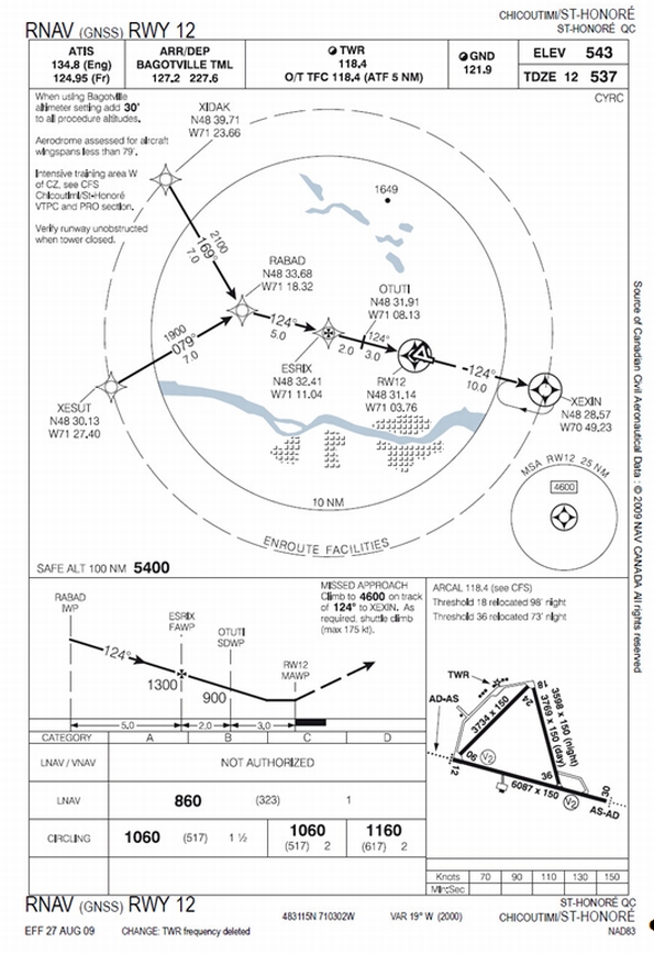
Appendix B — Graphical Forecast Area
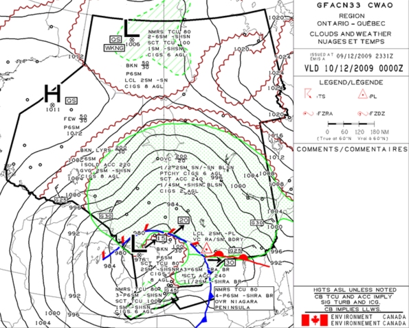
Appendix C — Examples of Descent Profiles
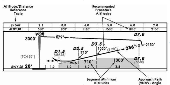


Appendix D — Safety Risks (ICAO Doc 9859 AN/474)