Collision with terrain
Bamaji Air Inc.
Cessna 208 Caravan, C-GIPR
Sioux Lookout, Ontario, 17 NM NNW
The Transportation Safety Board of Canada (TSB) investigated this occurrence for the purpose of advancing transportation safety. It is not the function of the Board to assign fault or determine civil or criminal liability. This report is not created for use in the context of legal, disciplinary or other proceedings. See Ownership and use of content. Masculine pronouns and position titles may be used to signify all genders to comply with the Canadian Transportation Accident Investigation and Safety Board Act (S.C. 1989, c. 3).
History of the flight
On 08 March 2022, the Bamaji Air Inc. (Bamaji) wheel-equipped Cessna 208 Caravan aircraft (registration C-GIPR, serial number 20800343) was conducting a series of visual flight rules (VFR) flights from Sioux Lookout Airport (CYXL), Ontario. At 1031,Footnote 1 after checking the aerodrome forecast (TAF) valid from 0900 to 2000, and the graphic area forecast (GFA) valid from 0600 to 1800, the pilot departed on a flight to an ice runway on Springpole Lake, Ontario, about 78 nautical miles (NM) north-northwest of CYXL. The aircraft returned to CYXL with 2 passengers at 1200.
In preparation for a second flight to Springpole Lake, the pilot loaded approximately 900 pounds of freight into the cabin and secured it under a cargo net. The aircraft had 750 pounds of fuel remaining on board, which was sufficient for the planned flight. The pilot and 1 passenger boarded the aircraft. The pilot occupied the left cockpit seat and the passenger occupied the right cockpit seat. Both occupants were wearing the available 5-point-harness safety belt system.
At 1250, a snow squallFootnote 2 began to move across CYXL, reducing ground visibility. The pilot taxied the aircraft to a position on the apron and waited for the fast-moving snow squall to pass. At 1301, the pilot taxied the aircraft to Runway 34 and took off in visual meteorological conditions.
The aircraft climbed to approximately 1800 feet above sea level (ASL), then, once clear of the control zone, it descended to approximately 1600 to 1700 feet ASL, roughly 500 to 600 feet above ground level (AGL), to remain below the overcast ceiling. As the aircraft began to cross Lac Seul, Ontario, the visibility straight ahead and to the west was good. However, when the aircraft was roughly midway across the lake, it encountered turbulence and immediately became enveloped in whiteout conditions generated by a snow squall.
The pilot turned his head to inspect the left wing and saw that ice appeared to be accumulating on the leading edge. He turned his attention back to the flight instruments and saw that the altimeter was descending rapidly. He then pulled back on the control column to stop the descent; however, within a few seconds, the aircraft struck the frozen surface of Lac Seul, approximately 17 NM north-northwest of CYXL (Figure 1).
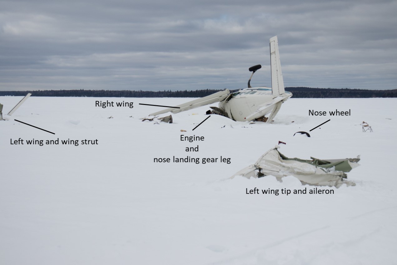
The aircraft was substantially damaged. There was no fire. The aircraft occupants received minor injuries. The Artex Model Me406 emergency locator transmitter (ELT) activated on impact and the signal was detected by the Cospas-Sarsat satellite system. The Joint Rescue Coordination Centre in Trenton, Ontario, re-tasked a Royal Canadian Air Force aircraft that was in the area and 3 search and rescue technicians (SAR Techs) parachuted into the site within 1 hour of the accident. The aircraft occupants and the SAR Techs were extracted from the site by a civilian helicopter later that day.
Weather information
The hourly weather report at 1200 for CYXL indicated:
- wind from 240° true (T) at 10 knots, gusting to 15 knots
- visibility 3 statute miles (SM) in light snow
- broken ceiling at 1000 feet AGL and overcast cloud layer at 1500 feet AGL
- temperature −3 °C, dew point −5 °C
At 1255, an updated weather report at CYXL indicated:
- wind from 240°T at 10 knots, gusting to 16 knots
- visibility ½ SM in snow
- vertical visibility of 400 feet
- temperature −3 °C, dew point −6 °C
Five minutes later, at 1300, the reported weather at CYXL indicated:
- wind from 260°T at 8 knots, gusting to 15 knots
- visibility 4 SM in light snow
- few clouds at 1200 feet AGL, broken ceiling at 2000 feet AGL, and overcast cloud layer at 6000 feet AGL
- temperature of −3 °C, dew point of −6 °C
The TAF issued at 0929 indicated that the conditions at CYXL from 0900 to 1300 would be:
- wind from 180°T at 10 knots, changing to 240°T at 12 knots, gusting to 22 knots between 1100 and 1300
- visibility 6 SM in light snow
- overcast ceiling at 1500 feet AGL
Temporarily between 0900 and 1300 the TAF indicated:
- visibility 2 SM in light snow showers
- overcast ceiling at 800 feet AGL
The TAF also indicated that from 1300 to 2000 the weather at CYXL was forecast to be:
- wind from 240°T at 12 knots, gusting to 22 knots
- visibility 4 SM in light snow
- broken ceiling at 2000 feet AGL and overcast at 4000 feet AGL
Temporarily between 1300 and 2000 the TAF indicated:
- visibility more than 6 SM in light snow
- ceiling overcast at 4000 feet AGL
The GFA, issued at 0532, indicated that weather in the CYXL area would be as follows:
- at 0600:
- broken cloud layers from 3000 to 12 000 feet ASL
- patchy areas of 4 SM in light snow
- isolated altocumulus castellanus clouds with tops at 12 000 feet, with associated visibility of 2 SM in light snow showers and ceilings of 800 feet AGL
- at 1200:
- broken cloud layers from 3000 to 12000 feet ASL
- patchy areas of 4 SM in light snow
- isolated altocumulus castellanus clouds with tops at 12 000 feet ASL, with associated visibility of 2 SM in light snow showers and ceilings of 1000 feet AGL
- intermittent areas with visibility of 2 SM to 4 SM in light snow with occasional towering cumulus clouds with tops at 9000 feet ASL, with associated areas of ¾ SM visibility in light snow showers and blowing snow and ceilings of 1500 feet AGL.
Meteorological assessment
The TSB requested that Environment and Climate Change Canada conduct a meteorological assessment of the conditions that the flight would have encountered.
According to the assessment,Footnote 3 at 1250 a line of convective cells, with radar echo tops between 7000 and 9000 feet ASL, extended northwest from CYXL. A convective cell began to move across CYXL at 1255. Radar reflectivity corresponded to a snowfall rate of about 1.4 centimetres per hour (cm/h), with radar echo tops at about 8200 feet ASL. At approximately 1255, a CYXL airport apron surveillance video showed that visibility was briefly reduced to about 1000 feet.
Between 1300 and 1310, a convective cell with higher radar reflectivities and echo tops up to 9000 feet ASL indicated that the visibility and ceiling were even lower at the crash site compared to what had been reported and observed at 1255 at CYXL.
As noted in the meteorological assessment,
convective cells that produce sudden, brief moderate-to-heavy snowfall such as this can also be referred to as snowsqualls. Snowsqualls can cause whiteout conditions in blowing snow and gusty surface winds.Footnote 4
At 1310, a few minutes after the crash, relatively intense radar echoes indicate that snow was falling at a rate of about 2 cm/h at the accident site (Figure 2).
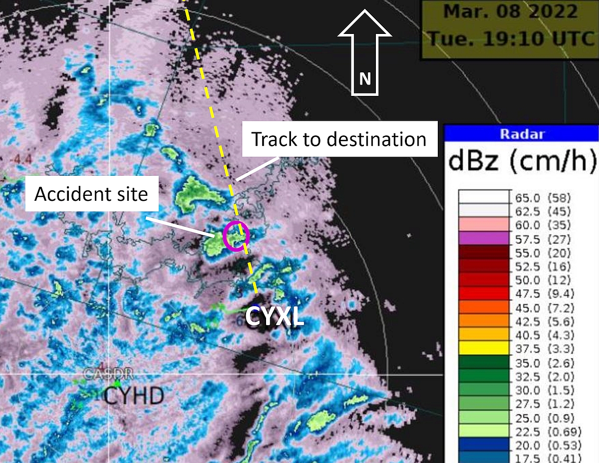
The assessment concluded that low visibility in snow squalls was likely at the time of the occurrence. In addition, the aircraft likely encountered moderate, possibly severe, mixed icing as well as moderate, possibly severe, turbulence at the time of the occurrence.
Pilot information
The pilot began his flying career in June 2019 at Bamaji. After working for another operator, he returned to Bamaji in early September 2021. He completed a Cessna C208 Caravan pilot competency check in November 2021 and began flying the wheel-equipped Cessna C208 Caravan when the float season ended.
The pilot held the appropriate licence and ratings for the VFR flight in accordance with existing regulations. He held a commercial pilot licence—aeroplane endorsed with single-engine, multi-engine, land, and sea classes. He also held a valid Category 1 medical certificate and a Group 1 instrument rating. However, since returning to Bamaji, he had not exercised the privileges of the instrument rating.
The pilot had accumulated approximately 1315 hours of total flying time. This included 126 hours on the occurrence aircraft, 48.3 of which were in the 30 days before the occurrence flight.
While at Bamaji, the pilot’s regular workday usually started at 0730 and ended at around 1600. On the day of the occurrence, his workday began at 0900. There is no indication that fatigue played a role in this occurrence.
Company information
Bamaji is approved by Transport Canada (TC) to operate under Subpart 702 (Aerial Work) and Subpart 703 (Air Taxi Operations) of the Canadian Aviation Regulations. The approval is limited to day VFR operations only.
Aircraft information
The Cessna 208 Caravan is a high-wing, fixed-landing-gear aircraft powered by a Pratt & Whitney Canada PT6A-114A turboprop engine equipped with a McCauley 3GFR34C703 propeller.
The occurrence aircraft was manufactured in 2001 and was equipped for night and instrument flight rules operations. Each cockpit seat was equipped with a 5-point-harness safety belt system consisting of a lap belt, crotch strap, and a double-strap inertia-reel-style shoulder harness.
According to the documentation for the occurrence flight, the aircraft’s centre of gravity was within the limits and its weight at takeoff was approximately 6698 pounds, which is below the maximum take-off weight of 8360 pounds. The aircraft had no known deficiencies, nor was there was any indication that an aircraft system contributed to the occurrence.
The aircraft was not equipped with a flight data recorder, cockpit voice recorder, or a flight tracking system, nor was it required to be by regulation. Consequently, it was not possible to reconstruct an accurate flight profile to assist the investigation.
Wreckage and impact information
Due to weather conditions and road closures, investigators were unable to access the site until 13 March 2022, 5 days after the occurrence.
The on-site inspection of several sections of the wing leading edges that had been protected by snow cover and sheltered from the sun revealed a few patches of very thin frost or ice. However, there were no indications of significant ice accumulation on the aircraft’s exposed critical surfaces either in photos taken within a few hours of the crash or during the TSB on-site examination of the wreckage.
The aircraft collided with the snow-covered frozen surface of Lac Seul at an elevation of approximately 1100 feet ASL, in a nose-down, left-wing-low attitude. The 2 to 3 feet of snow cover on the ice surface reduced the forces generated by the collision. The aircraft cockpit and cabin remained largely intact and provided a survivable space. The wreckage trail was approximately 550 feet long and oriented about 310°T, which is roughly 40° to the left of the direct bearing (350°T) from CYXL to the ice runway at Springpole Lake.
The fuselage was on its left side and snow had entered the cockpit through window openings, which hampered the pilot’s ability to exit the cockpit. Both cockpit seats remained attached to the floor-mounted seat rails. The lap belts, crotch straps, and shoulder harnesses had remained attached to their respective mounting points.
The barometric scale of the left altimeter was found set to 29.60 inches of mercury (inHg) and was within 0.04 inHg of the barometric pressure at CYXL on the day of the flight. The altitude indicated on the occurrence altimeter closely agreed with a serviceable altimeter adjusted to the same barometric setting. The altimeter had last been calibrated in April 2021.
Several primary flight instruments were retrieved and sent to the TSB Engineering Laboratory in Ottawa, Ontario, to determine if the gyroscopic instruments were operating and whether crash forces produced needle witness marks on the instrument faces. The examinations provided the following information:
- The turn coordinator and the flight command indicator (attitude indicator) gyroscopes were operating.
- Needle slap marks were present on the face of the airspeed indicator at 133 knots and at 125 knots.
- Needle scrape marks were present on the face of the vertical speed indicator between the 350 fpm descent and the 150 fpm climb graduations.
Visual flight rules flight into instrument meteorological conditions
The hazards associated with continuing VFR flight into instrument meteorological conditions are well documented. Accidents involving flights that depart under visual meteorological conditions and continue to a point where pilots lose visual reference with the horizon have a high fatality rate. According to data collected by the TSB, these types of flights have resulted in 100 accidents and 122 fatalities in Canada between 2000 and 2021.
Whiteout effect
The accident occurred while the aircraft was crossing a large, frozen, snow-covered lake at low altitude. Other than some small islands and the distant treed shorelines, there were few features to provide visual references. The terrain, coupled with the snow squalls that were passing through the area generated circumstances conducive to the creation of localized whiteout conditions. The American Meteorological Society’s Glossary of Meteorology defines whiteout as follows:
(Also called milky weather.) An atmospheric optical phenomenon in which the observer appears to be engulfed in a uniformly white glow.
Neither shadows, horizon, nor clouds are discernible; sense of depth and orientation is lost; only very dark, nearby objects can be seen. Whiteout occurs over an unbroken snow cover and beneath a uniformly overcast sky, when, with the aid of the snow blink effect, the light from the sky is about equal to that from the snow surface. Blowing snow may be an additional cause.Footnote 5
The Transport Canada Aeronautical Information Manual (TC AIM) provides the following information about whiteout:
whenever a pilot encounters […] whiteout conditions […], or even a suspicion of them, the pilot should immediately climb if at low level, or level off and turn towards an area where sharp terrain features exist. The flight should not proceed unless the pilot is prepared and competent to traverse the whiteout area on instruments.Footnote 6
Flying in whiteout conditions may result in a poorly defined visual horizon that will affect the pilot’s ability to detect and correct any changes in the aircraft’s attitude, altitude, or airspeed. Unless the pilot can successfully transition to instrument flight, the degradation of visual cues can eventually result in spatial disorientation which may lead to a loss of control.
TSB laboratory reports
The TSB completed the following laboratory report in support of this investigation:
- LP038/2022 – Instruments analysis
Safety messages
Continued flight under VFR into areas with reduced visual cues, such as areas with deteriorating weather or whiteout conditions, can lead to spatial disorientation and potentially a loss of control. All pilots—no matter how experienced they are—need to plan ahead and consider strategies to avoid such conditions, as well as have alternate plans should such conditions be encountered.
As seen in this occurrence, using a complete safety belt system can limit the extent of injury to occupants involved in an accident. Flight crews and passengers are encouraged to use the complete safety belt system, including available shoulder harnesses, at all times.
This report concludes the Transportation Safety Board of Canada’s investigation into this occurrence. The Board authorized the release of this report on . It was officially released on .