Collision with obstacle on takeoff
Privately registered
Piper Aircraft Corporation PA-28-180 (Cherokee), C-FYSZ
Canton Aerodrome, Ontario
The Transportation Safety Board of Canada (TSB) investigated this occurrence for the purpose of advancing transportation safety. It is not the function of the Board to assign fault or determine civil or criminal liability. This report is not created for use in the context of legal, disciplinary or other proceedings. See Ownership and use of content. Masculine pronouns and position titles may be used to signify all genders to comply with the Canadian Transportation Accident Investigation and Safety Board Act (S.C. 1989, c. 3).
History of the flight
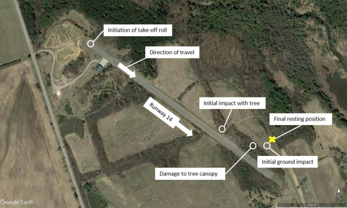
At approximately 2015Footnote 1 on 13 August 2022, during daylight hours, the privately registered Piper Aircraft Corporation PA-28-180 (Cherokee) aircraft (registration C-FYSZ, serial number 285205) began its take-off roll on Runway 14 at Canton Aerodrome (CTN7), Ontario, for a visual flight rules (VFR) flight to Ottawa/Rockcliffe Airport (CYRO), Ontario, with the pilot and 1 passenger on board.
Shortly after becoming airborne, when the aircraft had travelled approximately 1400 feet down the runway and was at a height of approximately 26 feet above ground level, the left wing struck a tree located approximately 40 feet to the left of the runway centreline. Then, the aircraft was seen to veer to the left before disappearing from view. The aircraft then struck multiple additional trees before colliding with terrain,Footnote 2 and came to rest approximately 220 feet to the left of the runway centreline (Figure 1).
At approximately 2045, bystanders reached the accident site and contacted emergency services, which arrived on site at 2100. Although both occupants were wearing safety belts with shoulder harnesses, they were fatally injured.
The aircraft’s 406 MHz emergency locator transmitterFootnote 3 activated, and the signal was received by the Joint Rescue Coordination Centre (JRCC) in Trenton, Ontario. There was no post-impact fire.
Aerodrome information
CTN7 is private aerodrome at an elevation of 520 feet above sea level (ASL). It has 1 runway surface (Runway 14/32), which is asphalt and is 1958 feet long and 40 feet wide. Prior permission is required before landing at the aerodrome.
Mature trees are present on both sides of the runway, starting approximately 600 feet before the departure end of Runway 14. The grassy area along the runway edges was maintained up to the runway edge lights on both sides of the runway. The runway had not been used regularly for approximately 5 years. A review of historic Google Earth imagery and the conditions observed following the occurrence show that, over the past 4 years, the tree canopy has expanded toward the edges of the runway, likely reducing the opening over the Runway 14 departure end. On 14 September 2022, Transport Canada received written notice that CTN7 was closed. Transport Canada indicated that CTN7 would soon be removed from publications.
Aircraft information
The PA-28-180 aircraft is a 4-seat, low-wing aircraft equipped with a carbureted Lycoming O-360-A4A engine, a Sensenich all-metal, 2-bladed, fixed-pitch propeller, and fixed tricycle landing gear. The aircraft had accumulated approximately 4034 hours of total air time before the occurrence. It had been registered to the Outaouais Flying Club inc. (a private flying club) since April 2005. The last annual inspectionFootnote 4 had been completed in March 2022.
Pilot information
The pilot held the appropriate licence and met the recency requirements for the flight in accordance with existing regulations. He had a private pilot licence — aeroplane with a night rating and a Group 3 instrument rating; his medical certificate was valid. He had accumulated approximately 600 total flying hours and approximately 190 of those hours were on the occurrence aircraft. The occurrence takeoff was the pilot’s third takeoff from Runway 14 at CTN7; the previous one was in October 2019.
Weather information
The weather was suitable for the VFR flight. The automatic hourly aerodrome routine meteorological report issued at 2000 for Peterborough Airport (CYPQ), Ontario, the closest aerodrome to the accident site, located 14 nautical miles north of CTN7, reported the winds from 200° true at 3 knots, visibility 9 statute miles, no clouds, temperature 20 °C, and dew point 10 °C. On the day of the occurrence, the sunset in Canton was at 2035.
Accident site and aircraft wreckage
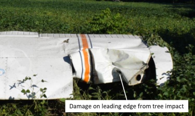
The aircraft struck the ground in a nearly vertical, nose-down attitude; the nose and right wing impacted the ground first, followed by the lower right side of the fuselage. The right wing was nearly separated from the aircraft, and had folded back along the right side of the fuselage. The engine was displaced significantly to the left of the fuselage centreline, and the left wing was relatively undamaged by the ground impact. There were signs of tree strikes along both wing leading edges, the most significant of which was on the outboard leading edge of the left wing, approximately 2 feet inboard from the wing tip (Figure 2).
The aircraft systems were examined to the degree possible on site, and no indication of a malfunction was found. Damage to the propeller was consistent with power being produced at the time of impact, although the amount of power could not be determined. Due to the damage to the nose section, the position of the engine controls could not be determined with certainty.
The ignition key was found in the BOTH position. The stabilator was trimmed slightly nose up, which is consistent with a take-off configuration, and the flaps were found retracted. The fuel selector was selected to the right tank. Both the left and right fuel tanks were compromised and leaking fuel. Approximately 35 L of aviation fuel (AVGAS) were recovered from both tanks.
The aircraft was being operated within its weight and balance limitations.
The aircraft was not equipped with a lightweight data recorder, nor was it required to be by regulation. No data was available from the global positioning system on board the aircraft. Given the absence of data, the investigation could not determine the complete sequence of events that led to the aircraft deviating slightly to the left during takeoff, which resulted in the impact with a tree followed by a loss of control and collision with terrain.
This report concludes the Transportation Safety Board of Canada’s investigation into this occurrence. The Board authorized the release of this report on . It was officially released on .