Collision with terrain
Privately registered
Cessna 150G, C-FQCS
Bainsville, Ontario
The Transportation Safety Board of Canada (TSB) investigated this occurrence for the purpose of advancing transportation safety. It is not the function of the Board to assign fault or determine civil or criminal liability. This report is not created for use in the context of legal, disciplinary or other proceedings. See Ownership and use of content. Masculine pronouns and position titles may be used to signify all genders to comply with the Canadian Transportation Accident Investigation and Safety Board Act (S.C. 1989, c. 3).
History of the flight
On the evening of 05 December 2022, the privately registered Cessna 150G aircraft (registration C-FQCS, serial number 15066475) was conducting a night visual flight rules (VFR) flight from Salaberry-de-Valleyfield Aerodrome (CSD3), Quebec, to Cornwall Regional Aerodrome (CYCC), Ontario, with the pilot and 1 passenger on board. The passenger was the owner of the aircraft, but he did not possess a pilot licence or permit. He had flown with the occurrence pilot on several occasions.Footnote 1
The aircraft departed CSD3 at 1952,Footnote 2 turned toward the northwest, and climbed to 1500 feet above sea level. After crossing the St. Lawrence River, the aircraft turned to the southwest toward CYCC, flying north of the shoreline along Quebec provincial Highway A20 (Figure 1).
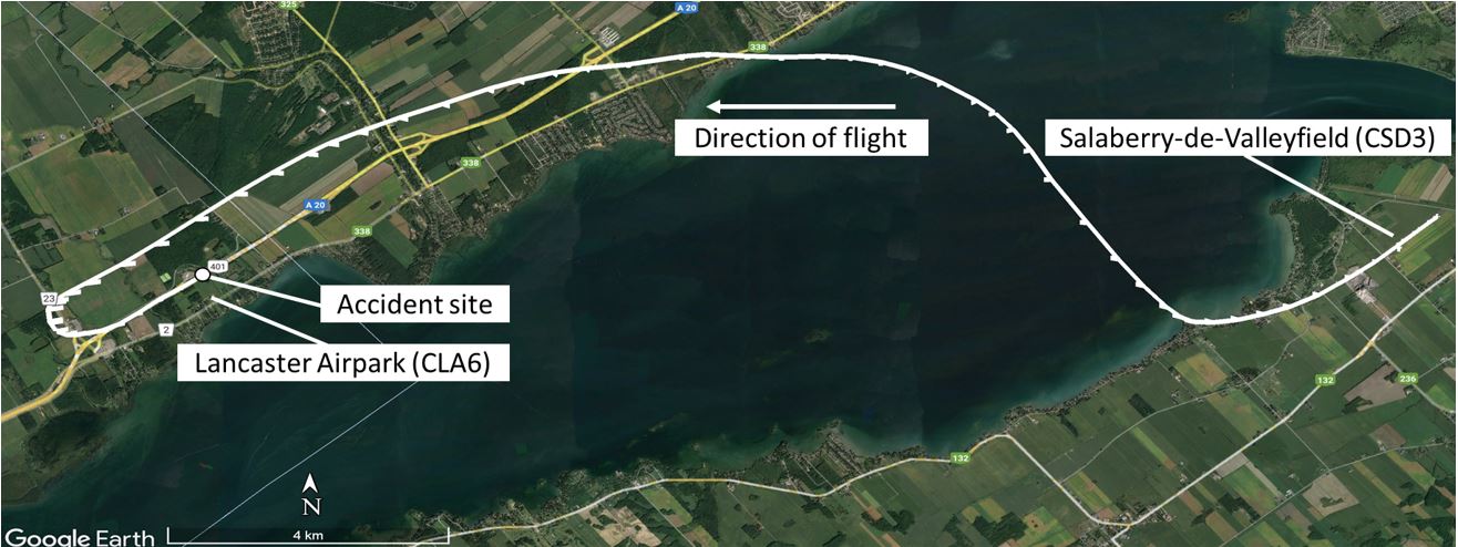
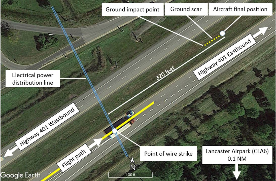
At approximately 2001, shortly after the aircraft crossed the Ontario–Quebec provincial border, the pilot heard a noise and the engine lost power. The pilot, seated in the right seat, conducted a descending 180° left turn toward the northeast and aligned the aircraft with Ontario provincial Highway 401. At 2003, the aircraft struck a set of 4 electrical power distribution lines before colliding with terrain in the grassy median between the highway’s eastbound and westbound lanes, and coming to rest in an inverted position (Figure 2). There was no fire. The accident site was 0.1 nautical miles (NM) north of Lancaster Airpark (CLA6), Ontario. CLA6 is not equipped with runway lighting.
The aircraft’s emergency locator transmitter (ELT) activated, but no signal was detected by the Cospas-Sarsat system. A person who observed the accident reported it to the Ontario Provincial Police, who notified the Joint Rescue Coordination Centre in Trenton, Ontario, at 2016. The pilot and passenger received serious injuries and were transported to a hospital in Ottawa, Ontario. The aircraft was substantially damaged.
Pilot information
The pilot had obtained a pilot licence – glider in October 2014 and a commercial pilot licence – aeroplane in July 2022. His Category 1 medical certificate was valid. He also held 2 ratings: he had obtained a multi-engine class rating in May 2021, and a flight instructor rating – glider in July 2021. He was in the process of obtaining a flight instructor rating – aeroplane.
Records indicate that the pilot had accumulated 416.7 hours total flight time in airplanes, with 72.3 total hours flown at night. He had accumulated 278.1 hours in single-engine airplanes, and 50.7 of those hours were flown at night. He had accumulated 37.3 hours in Cessna 150 aircraft and approximately 220 hours in Cessna 152 aircraft. In addition, he had accumulated 99.2 hours of flight time in gliders.
Records indicate that the pilot had completed 5 night takeoffs and 5 night landings within the last 6 months in a multi-engine airplane. However, he had not done so in the same class of aircraft as the occurrence aircraft (single-engine aeroplane). As a result, he did not meet the Canadian Aviation Regulations (CARs) recency requirements to carry a passenger at night in the occurrence aircraft.
Clause 401.05 (2)(b)(i)(B) of the CARs requires the holder of a flight crew permit or licence to complete “at least […] five night take-offs and five night landings, if the flight is conducted wholly or partly by night”Footnote 3 in the same category and class of aircraft as the aircraft being flown.
In section 101.01 of the CARs, a category is defined as follows: “when used in reference to flight crew licensing, the classification of aircraft as an aeroplane, a balloon, a glider, a gyroplane, a helicopter or an ultra-light aeroplane.”Footnote 4
In that same section of the CARs, a class “in relation to the classification of aeroplanes, means aeroplanes having similar operating characteristics to single-engined aeroplanes, multi-engined aeroplanes, centre-line thrust aeroplanes, land aeroplanes or sea aeroplanes.”Footnote 5
The pilot met all other recency requirements stipulated in section 401.05 of the CARs.
Aircraft information
The occurrence aircraft was manufactured in 1967. The aircraft journey log indicated that the aircraft had accumulated 5670 flight hours since new. The last annual inspection was completed on 04 May 2021. The aircraft had undergone maintenance on 26 October 2022, and again on 21 November 2022. The maintenance covered some, but not all, aspects of the annual inspection that are required by appendices B and C of CARs Standard 625.
Under paragraph 605.86(1)(a) of the CARs, aircraft are required to be maintained in accordance with “a maintenance schedule that conforms to the Aircraft Equipment and Maintenance Standards.”Footnote 6 For the occurrence aircraft, these standards required that the aircraft be maintained “at intervals not to expire later than the last day of the 12th month, following the preceding inspection.”Footnote 7 Although there were communications between the owner and the pilot before the occurrence flight indicating that all required maintenance for the annual inspection had been done, there were no records made available to indicate that an annual inspection was completed.
The aircraft liability insurance was valid until 24 September 2022. Therefore, the aircraft was not insured at the time of the occurrence as required by regulations.Footnote 8
The occurrence aircraft was not equipped with a flight data recorder or a cockpit voice recorder, and neither was required by regulation. The aircraft was equipped with a global positioning system (GPS), a Garmin GPSMAP 295. The GPS was recovered and the aircraft flight data for the occurrence flight were successfully downloaded.
The aircraft was also equipped with an ARTEX ELT (model 345) that was manufactured in August 2022. This model of ELT transmits on frequencies 121.5 MHz and 406 MHz. No ELT signal was detected by the Cospas-Sarsat system at the time of the occurrence. However, during the post-occurrence aircraft recovery, it was established that the ELT was transmitting. The investigation was unable to determine why no signal had been detected.
Impact and wreckage information
The occurrence aircraft struck a set of electrical power distribution lines before colliding with terrain. The aircraft damage is consistent with the aircraft having impacted the ground inverted on its right side. The aircraft then slid and came to rest—still inverted—on the grassy median of Ontario provincial Highway 401, approximately 320 feet from the wire strike location.
The aircraft was substantially damaged and there was a strong smell of fuel at the site. Remnants of one power line, which had been struck by the left-wing leading edge, were found wedged between the flap and the aileron.
The engine sustained some damage due to impact. Damage to the propeller indicated it was rotating at the time of impact; however, it could not be determined how much, if any, engine power was being produced.
The engine was disassembled and examined to the extent possible at the TSB’s regional facility in Richmond Hill, Ontario. There were no signs of a catastrophic engine failure or of mechanical failure of any major engine components. The carburetor and magnetos were examined at an overhaul facility and found to be serviceable. The carburetor heat system was examined, but due to the extent of the damage, it could not be determined if the carburetor heat was selected to the ON position, or if the system was functioning at the time of the occurrence.
Weather information
The weather was suitable for the night VFR flight. The aerodrome routine meteorological report (METAR) issued at 2000 for Montréal/Pierre Elliott Trudeau International Airport (CYUL), Quebec (30 NM east of the occurrence site), indicated winds from the southeast at 11 knots, a visibility of 15 statute miles, a broken ceiling at 15 000 feet above ground level (AGL), a temperature of 3 °C, and a dew point of −5 °C.
The automatic METAR (METAR AUTO) issued at 1953 for Massena International-Richards Field Airport (KMSS), New York, United States (26 NM southwest of the occurrence site), reported winds generally from the south at 6 knots, clear skies, a visibility of 10 statute miles, a temperature of 6 °C, and a dew point of −9 °C.
Carburetor icing
Carburetor icing is a phenomenon where water vapour in the air freezes and adheres to internal surfaces of the carburetor. This occurs because the temperature of air entering the carburetor is reduced by the effect of fuel vaporization and by the decrease in air pressure caused by the Venturi effect. If the air temperature in the carburetor drops below freezing, ice may form on internal surfaces of the carburetor, including the throttle valve.
To overcome carburetor icing, aircraft manufacturers provide a system to heat the incoming air and prevent ice accumulation. If significant ice is allowed to develop within the carburetor and full heat is applied to melt it, the resultant water flow through the engine causes the engine to run rough and to lose further power, and it may even cause the engine to quit. Unchecked, the ice can quickly lead to a complete engine failure.
Ice that forms in a carburetor during flight rarely remains after a crash, making carburetor ice difficult to identify as a cause of power loss. Nonetheless, accidents and incidents involving carburetor icing, where engine power loss due to carburetor ice has been suspected, are prevalent in aviation.Footnote 9,Footnote 10 To help determine whether atmospheric conditions are likely to produce carburetor ice, charts that compare outside ambient temperature, dew point, and relative humidity have been produced (Figure 3). However, it is important to note that the formation of carburetor ice is also possible in conditions outside those depicted on the charts.Footnote 11
![Carburetor icing potential based on ground-level weather conditions near Montréal/Pierre Elliott Trudeau International Airport, and Massena International-Richards Field Airport (Source: Transport Canada, TP 14371, Transport Canada Aeronautical Information Manual [TC AIM], AIR – Airmanship [06 October 2022], section 2.3, with TSB annotations)](/sites/default/files/eng/rapports-reports/aviation/2022/a22o0165/images/a22o0165-figure-03.jpg)
Although the chart indicates that the temperature and dew point at KMSS were not conducive to carburetor icing at the time of the occurrence, it indicates that there was potential for serious carburetor icing at descent power in the CYUL area.
Marking and lighting of obstacles to air navigation
According to the CARs, marking and lighting are required for any “building, structure or object that constitutes an obstacle to air navigation.”Footnote 12 The electrical power distribution poles installed alongside Ontario provincial Highway 401 near the occurrence site are approximately 15 m (50 feet) tall and the wires that cross the highway are lower than the top of the towers. Although they are within a 6 km radius of CLA6, they are not defined as obstacles to air navigation, according to CARs,Footnote 13 given that their height does not exceed 90 m (296 feet) AGL and, therefore, they are not required to be marked or lit.
Night visual flight
The principle behind day and night VFR flight is that the pilot uses visual cues (e.g., visual horizon, ground references) outside the aircraft to determine the aircraft’s attitude. Flying VFR at night involves numerous risks owing to poor visual cues. Fewer visual cues combined with a reduced ability to see at night make it difficult to identify terrain and obstacles to navigation. The surrounding environmental and lighting conditions must therefore be sufficient to allow the pilot to see these visual cues.
The conditions experienced during the occurrence flight were such that visual reference to the surface was possible because of the cultural lighting provided by the Ontario and Quebec provincial highways, and various towns along the planned route. However, it would have been difficult to see the unlit power lines crossing Highway 401 or to see CLA6’s grass runway parallel to that highway.
TSB laboratory report
The TSB completed the following laboratory report in support of this investigation:
- LP131/2022 – NVM Data Recovery - GPS
Safety messages
Pilots and aircraft owners are reminded that the CARs requirements for annual inspections are in place to ensure that aircraft are maintained in accordance with airworthiness standards and, as a result, are safe for operation.
Based on the conditions at the time of the occurrence, there was a potential for serious carburetor icing with descent power. Even though the investigation was unable to determine if carburetor icing was a factor in this occurrence, pilots are reminded that carburetor icing can occur at various temperatures and all engine power settings.
This report concludes the Transportation Safety Board of Canada’s investigation into this occurrence. The Board authorized the release of this report on . It was officially released on .