Loss of control and collision with terrain
AFS Aerial Photography Inc.
Cessna 152, C-GRCA
Claresholm Industrial Aerodrome (CEJ4), Alberta
The Transportation Safety Board of Canada (TSB) investigated this occurrence for the purpose of advancing transportation safety. It is not the function of the Board to assign fault or determine civil or criminal liability. This report is not created for use in the context of legal, disciplinary or other proceedings. See Ownership and use of content. Masculine pronouns and position titles may be used to signify all genders to comply with the Canadian Transportation Accident Investigation and Safety Board Act (S.C. 1989, c. 3).
Background information
On 27 July 2023, the pilot of the Cessna 152 aircraft (registration C-GRCA, serial number 15279738), operated by AFS Aerial Photography Inc., was flying west of Lethbridge, Alberta, when the engine lost power because of fuel exhaustion. The pilot conducted a forced landing on a road 26 nautical miles west-northwest of Lethbridge. During the landing roll, the right wing struck a sign post. The wings were removed from the aircraft before it was transported via road to the Claresholm Industrial Aerodrome (CEJ4), Alberta, for repairs. The left wing was reinstalled and a repaired replacement right wing was installed.
History of the flight
On 28 August 2023, the aircraft was conditionally released by the maintenance provider pending a satisfactory test flight for straight and level flight. Following completion of the satisfactory test flight, the pilot was to provide the final signature to release the aircraft back into service.
At about 1600,Footnote 1 the pilot began pre-flight preparations for the test flight and loaded equipment and personal belongings onto the aircraft. A fuel leak was noticed near the fuel drain on the right fuel tank and so the fuel tanks were filled to maximum capacityFootnote 2 to troubleshoot the leak. The leak was rectified by maintenance, and once again the aircraft was conditionally released for the test flight.
Company management instructed the pilot to do a longer run-up to ensure there were no mechanical issues and, after takeoff, to fly near the aerodrome for 20 minutes. During the pre-flight inspection, a rough paint texture was noted on the right-wing leading edge. No other anomalies were noted, and the flight controls were deemed to be free and correct.
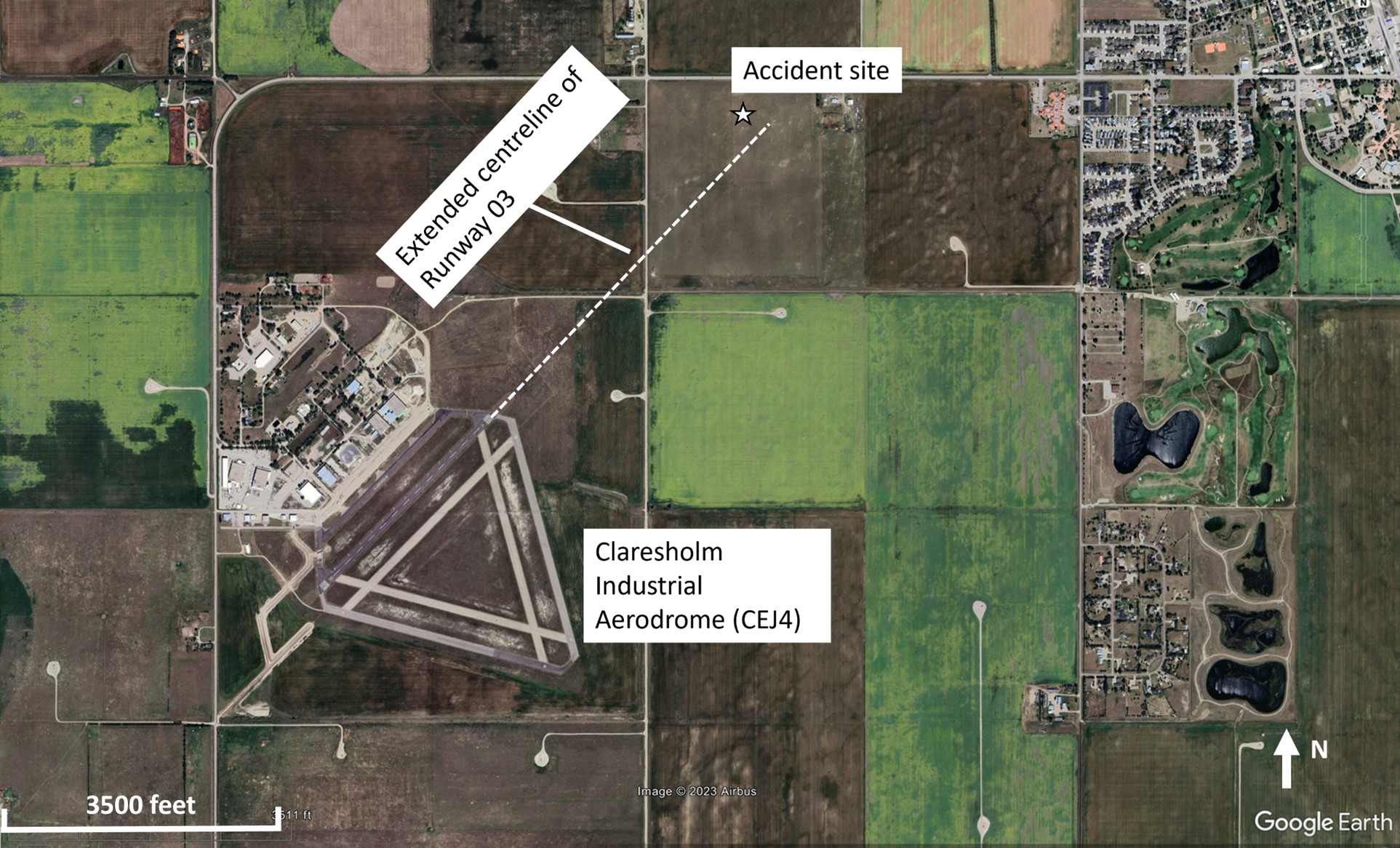
The pilot occupied the right seat, which was the seat that she normally flew from when conducting aerial photography. After the run-up, the pilot taxied into position on Runway 03 and commenced the takeoff at 1928. The aircraft was observed getting airborne in the first third of the runway (about a 1000-foot take-off roll) and commencing a shallow climb on the runway track. At about 1 nautical mile from the aerodrome, several eyewitnesses described the aircraft in a shallow climb and then turning sharply to the left before entering a steep turning descent.
The aircraft impacted the ground 5200 feet from the departure end of Runway 03 and 215 feet left of the extended centreline (Figure 1). Several eyewitnesses were on scene shortly after the accident, and police and fire rescue services followed 5 minutes later. The pilot received fatal injuries. The aircraft was substantially damaged; there was no post-impact fire. The 121.5 MHz emergency locator transmitter activated.
Aircraft information
Ground scars and damage to the aircraft were consistent with the aircraft contacting the ground in a spin to the left. The flaps were in the up position, the elevator trim was in the take-off position, the throttle control was set to full power, and the mixture control was set to full rich. Damage to the propeller was consistent with power being produced at impact. At the accident site, first responders noted a strong odour of fuel and fuel leaking from the fuel tanks. The burst damage to both main fuel tanks was consistent with a significant amount of fuel being in the fuel tanks at impact.
The aircraft was equipped with a digital engine monitor.Footnote 3 The engine monitor records time, outside air temperature, fuel flow, and, for each cylinder, exhaust gas temperature and cylinder head temperature. The monitor recorded an increase in fuel flow at a time of 1928:20 that stabilized at about 8 U.S. gallons per hour, which is consistent with take-off power. The recording ceased 93 seconds later. In those 93 seconds, the fuel flow and engine temperatures were consistent with the engine producing power and were similar to previous flights recorded by the monitor.
When TSB investigators arrived on site, they completed an initial evaluation of the aircraft. All aircraft components were located in close proximity, including both wings and vertical and horizontal stabilizers. The continuity of the flight control system was verified between those sections that failed in overload due to impact forces or were affected by post-accident rescue activity.
After the wreckage had been recovered to the TSB facility in Edmonton, Alberta, a more detailed examination of the airframe, flight controls, pitot system, stall warning system, and engine was completed. Particular attention was given to those components and systems that could have contributed to a stall/spin scenario; no anomalies were noted.
Examination of the seat rails showed that the seat position at the time of impact was appropriate for the pilot to be able to reach the flight controls. The relevant seat rail airworthiness directive,Footnote 4 which requires repetitive inspections and replacement of parts in the seat rail system, had been complied with and checked in the recent maintenance. The seat had not moved during the takeoff and climbout.
A review of the records of the maintenance performed as a result of the 27 July 2023 occurrence indicated that the required work had been completed in accordance with the manufacturer’s maintenance manual. This maintenance included a leak check of the pitot system, a functional check of the stall warning system, and an independent check of the flight control systems affected by the maintenance activities surrounding the reinstallation of both wings.
A weight-and-balance calculation was performed, and the aircraft was within the weight-and-balance envelope. The aircraft weighed 1543 pounds at takeoff, which is 127 pounds below its maximum gross take-off weight.
In summary, notwithstanding the extent of the damage, the investigation did not discover anything mechanical that could have led to the aerodynamic stall and spin.
Weather information
The closest weather station to the accident site is an Environment and Climate Change Canada – Meteorological Service of Canada’s weather station located near CEJ4 that is at an elevation of 3310 feet above sea level (ASL). At 1900, 30 minutes before the accident, the station reported:
- Temperature 29.5 °C
- Dew point 3.8 °C
- Wind 120° true (T) at 15 km/h
- Station pressure 90.37 kPa
At 2000, 30 minutes after the accident, the station reported:
- Temperature 24.5 °C
- Dew point 5.3 °C
- Wind 120°T at 11 km/h
- Station pressure 90.35 kPa
Aircraft performance
Interpolating the weather information above for the time of the accident, the density altitude at CEJ4 would have been 5347 feet ASL at the time of the accident. The occurrence aircraft manufacturer advises that to achieve maximum engine rpm, the mixture control should be leanedFootnote 5 anytime that operations are conducted above 3000 feet ASL.
Air density decreases with increased altitude and temperature.Footnote 6 Therefore, the combination of high temperature and high elevation can drastically reduce the aerodynamic and engine performance of the airplane in the following ways:
The horsepower output of the engine is decreased because its fuel/air mixture is reduced. The propeller develops less thrust because the blades, as airfoils, are less efficient in the thin air. The wings develop less lift because the thin air exerts less force on the airfoils. As a result, the take-off distance is substantially increased, climb performance is substantially reduced and may, in extreme situations, be non-existent.Footnote 7
According to the Cessna 152 pilot’s operating handbook (POH),Footnote 8 with the aircraft at its maximum take-off weight, flaps up, mixture leaned for maximum engine rpm, and for the density altitude at the time of the occurrence, a maximum rate of climb of 475 fpm can be achieved at an indicated airspeed of 65 knots.
Based on the time stamp on the engine monitor and eyewitness accounts, the average ground speed from the application of take-off power to the spin entry was estimated to be 53 knots. Applying the wind speed and direction and atmospheric conditions results in a 50-knot average calibrated airspeed (46-knot indicated airspeed).Footnote 9 The stall speed when the aircraft is at its maximum take-off weight, with flaps up, and wings level is 48-knot calibrated airspeed.Footnote 10
The aircraft was not equipped with an automatic dependent surveillance – broadcast (ADS-B) transmitter nor was the flight observed on radar. The aircraft did not have any GPS (global positioning system) equipment on board that recorded a flight track. Besides the time recorded on the digital engine monitor, there was no data available to determine a flight path.
Spins
A spin is an autorotation that develops after an aggravated stallFootnote 11 wherein the aircraft follows a downward corkscrew path. Entry into a spin can be either intentional or unintentional and can occur at practically any airspeed, as long as there is a sufficient yaw rate while the aircraft is stalled.
The spin recovery outlined in the Cessna 152 POH is the following [emphasis in original]:
- PLACE AILERONS IN NEUTRAL POSITION.
- RETARD THROTTLE TO IDLE POSITION.
PLACE AILERONS IN NEUTRAL POSITION.
APPLY AND HOLD FULL RUDDER OPPOSITE TO THE DIRECTION OF ROTATION.
- JUST AFTER THE RUDDER REACHES THE STOP, MOVE THE CONTROL WHEEL BRISKLY FORWARD FAR ENOUGH TO BREAK THE STALL. Full down elevator may be required at aft center of gravity loadings to assure optimum recoveries.
- HOLD THESE CONTROL INPUTS UNTIL ROTATION STOPS. Premature relaxation of the control inputs may extend the recovery.
- AS ROTATION STOPS, NEUTRALIZE RUDDER, AND MAKE A SMOOTH RECOVERY FROM THE RESULTING DIVE.Footnote 12
The POH also states that “[a]t least 1000 feet of altitude loss should be allowed for a 1-turn spin and recovery.”Footnote 13
Because of a lack of flight path data, the investigation could not determine a reason for the aerodynamic stall and spin.
AFS Aerial Photography Inc.
Based in London, Ontario, AFS Aerial Photography Inc. has been conducting aerial photography since 1963 and had 6 aircraft at the time of the occurrence. The business is operated under Subpart 702 of the Canadian Aviation Regulations. The company conducts photo flights across Canada. The pilots are commercially licensed, and the aircraft are privately registered. Pilots are given a pilot competency check and training on how to conduct the photo flights.
The flights are conducted at 500-700 feet above ground level as the pilot takes photos of properties. The photos are then brought to the property owners for possible purchase.
Pilot experience
This was the occurrence pilot’s 1st summer with the company. When she was hired in June 2023, she held a valid Category 1 medical certificate, a commercial pilot licence – aeroplane, a multi-engine rating, and a Group 1 instrument rating, and she had accumulated 256 hours of flight time. She then acquired 135 hours with the company. At the time of the occurrence, her total flight time was 391 hours, predominantly on the Cessna 150/152 aircraft. According to the information collected during the investigation, the pilot’s commercial pilot licence was valid at the time of the accident.
The pilot had not flown in the 31 days before the accident because the aircraft she was assigned to was undergoing repairs for the damaged right wing. Fatigue was not considered a factor in the occurrence.
Safety messages
Pilots are reminded to consult their aircraft’s POH for proper setting of the mixture control appropriate for the density altitude to ensure maximum power is available for takeoff and climbout.
Higher density altitudes result in penalties against take-off distance and climb performance. Pilots are reminded to review the POH when planning a flight in warmer temperatures and at higher airport elevations (high density altitudes) so that they are aware of these penalties.
This report concludes the Transportation Safety Board of Canada’s investigation into this occurrence. The Board authorized the release of this report on . It was officially released on .